Mayfield geodata
Mayfield (Kentucky) is a seat of a second-order administrative division; located in United States in America/Chicago (GMT-5) time zone. With population of 10,080 people, there are 4439 cities with bigger population in this country. Compared to other cities in United States, 67.1% of cities are located further ↑North; 55.2% of cities are located further →East and 61.7% of cities have higher elevation than Mayfield. Note1


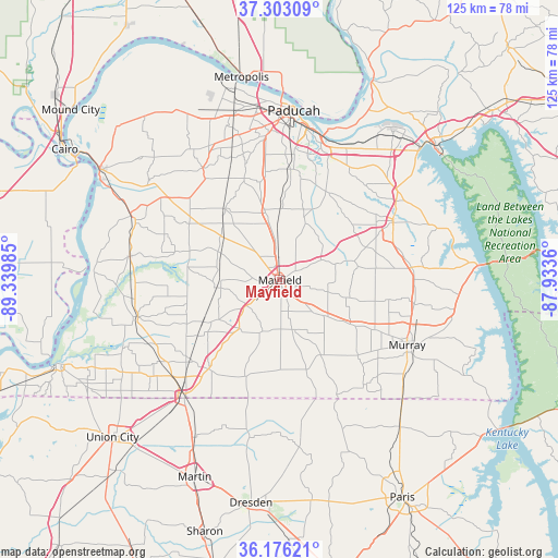
Mayfield GPS coordinates[2]
36° 44' 30.192" North, 88° 38' 12.192" West
| Map corner | latitude | longitude |
|---|---|---|
| Upper-left | 37.30309°, | -89.33985° |
| Center: | 36.74172°, | -88.63672° |
| Lower-right: | 36.17621°, | -87.9336° |
| Map W x H: | 125.3×125.3 km | = 77.9×77.9mi |
| max Lat: | 71.29058° ⇑67.1% North |
| Mayfield: | 36.74172° |
| min Lat: | ⇓32.9% South 19.06759° |
| min Long | Mayfield | max Long |
| -171.73463° | -88.63672° | -66.98998° |
| W 44.8%⇐ | ⇒55.2% E |
Elevation
Elevation of Mayfield is 146 m = 479 ft, and this is 148.8 m = 488 ft below average elevation for this country.
| Max E: |
3189 m = 10463 ft | 61.7% |
| Avg. | 294.8 m = 967 ft | |
| Mayfield | 146 m = 479 ft | |
Min E: |
-60 m = -197 ft | 38.3% |
See also: United States elevation on elevation.city.
Geographical zone
Mayfield is located in North temperate zone (between Tropic of Cancer and the Arctic Circle). Distance of this Northern Tropic circle is 1479.4 km =919.3 mi to South.| Distance of | km | miles | from Mayfield |
|---|---|---|---|
| North Pole | 5921.8 | 3679.6 | to North |
| Arctic Circle | 3315.9 | 2060.4 | to North |
| Tropic Cancer | 1479.4 | 919.3 | to South |
| Equator | 4085.3 | 2538.5 | to South |


Nearby cities:
15 places around Mayfield: (largest is in red/bold)
• Bardwell
36.2 km =22.5 mi,  293°
293°
• Benton
28.6 km =17.8 mi,  63°
63°
• Clinton
32.9 km =20.4 mi,  255°
255°
• Farley
34.4 km =21.4 mi,  10°
10°
• Fulton
33.9 km =21.1 mi,  218°
218°
• Hardin
30.5 km =19 mi,  85°
85°
• Hendron
33.1 km =20.6 mi,  1°
1°
• Ledbetter
36.9 km =22.9 mi,  22°
22°
• Massac
31.7 km =19.7 mi,  344°
344°
• Murray
32.2 km =20 mi,  116°
116°
• Paducah
38.1 km =23.7 mi, 4°
• Reidland
32.1 km =19.9 mi, 16°
• South Fulton
34.2 km =21.3 mi, 218°
• Symsonia
22.4 km =13.9 mi,  27°
27°
• Wingo
14.3 km =8.9 mi, 219°
Sources, notices
• [Note1] Compared only with cities in United States existing in our database
• [Src1] Map data: © OpenStreetMap contributors (CC-BY-SA)
• [Src2] Other city data from geonames.org with taken over terms of usage.
• [Src3] Geographical zone / Annual Mean Temperature by Robert A. Rohde @ Wikipedia
