Bromley geodata
Bromley (Kentucky) is a populated place; located in United States in America/New_York (GMT-4) time zone. With population of 776 people, there are 18014 cities with bigger population in this country. Compared to other cities in United States, 57.8% of cities are located further ↑North; 56.2% of cities are located further ←West and 68.7% of cities have lower elevation than Bromley. Note1


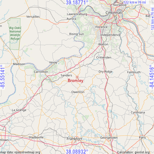
Bromley GPS coordinates[2]
38° 38' 26.232" North, 84° 50' 53.808" West
| Map corner | latitude | longitude |
|---|---|---|
| Upper-left | 39.18771°, | -85.55141° |
| Center: | 38.64062°, | -84.84828° |
| Lower-right: | 38.08932°, | -84.14516° |
| Map W x H: | 122.1×122.1 km | = 75.9×75.9mi |
| max Lat: | 71.29058° ⇑57.8% North |
| Bromley: | 38.64062° |
| min Lat: | ⇓42.2% South 19.06759° |
| min Long | Bromley | max Long |
| -171.73463° | -84.84828° | -66.98998° |
| W 56.2%⇐ | ⇒43.8% E |
Elevation
Elevation of Bromley is 279 m = 915 ft, and this is 15.8 m = 52 ft below average elevation for this country.
| Max E: |
3189 m = 10463 ft | 31.3% |
| Avg. | 294.8 m = 967 ft | |
| Bromley | 279 m = 915 ft | |
Min E: |
-60 m = -197 ft | 68.7% |
See also: United States elevation on elevation.city.
Geographical zone
Bromley is located in North temperate zone (between Tropic of Cancer and the Arctic Circle). Distance of this Northern Tropic circle is 1690.5 km =1050.4 mi to South.| Distance of | km | miles | from Bromley |
|---|---|---|---|
| North Pole | 5710.6 | 3548.4 | to North |
| Arctic Circle | 3104.7 | 1929.2 | to North |
| Tropic Cancer | 1690.5 | 1050.4 | to South |
| Equator | 4296.4 | 2669.7 | to South |


Nearby cities:
15 places around Bromley: (largest is in red/bold)
• Campbellsburg
33.4 km =20.8 mi,  247°
247°
• Carrollton
29.1 km =18.1 mi,  278°
278°
• Crittenden
26.4 km =16.4 mi,  53°
53°
• Dry Ridge
22.9 km =14.2 mi,  78°
78°
• New Castle
36.2 km =22.5 mi,  230°
230°
• Owenton
11.6 km =7.2 mi,  177°
177°
• Pleasureville
40.2 km =25 mi,  215°
215°
• Providence
33.2 km =20.6 mi,  257°
257°
• Rising Sun
34.3 km =21.3 mi,  359°
359°
• Union
36.9 km =22.9 mi,  23°
23°
• Verona
25.6 km =15.9 mi,  39°
39°
• Vevay
22.4 km =13.9 mi,  302°
302°
• Walton
33.3 km =20.7 mi, 38°
• Warsaw
16.5 km =10.3 mi,  343°
343°
• Williamstown
25 km =15.5 mi,  90°
90°
Sources, notices
• [Note1] Compared only with cities in United States existing in our database
• [Src1] Map data: © OpenStreetMap contributors (CC-BY-SA)
• [Src2] Other city data from geonames.org with taken over terms of usage.
• [Src3] Geographical zone / Annual Mean Temperature by Robert A. Rohde @ Wikipedia
