Owenton geodata
Owenton (Kentucky) is a seat of a second-order administrative division; located in United States in America/New_York (GMT-4) time zone. With population of 1,550 people, there are 13475 cities with bigger population in this country. Compared to other cities in United States, 58.5% of cities are located further ↑North; 56.3% of cities are located further ←West and 72% of cities have lower elevation than Owenton. Note1


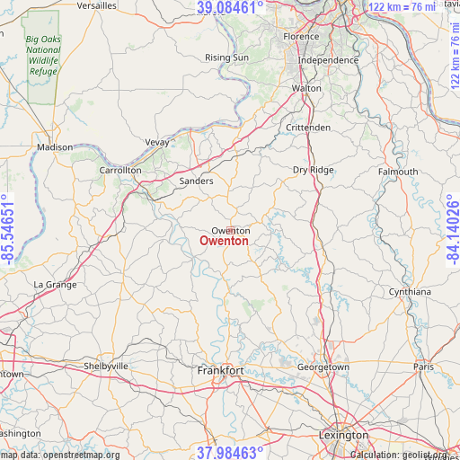
Owenton GPS coordinates[2]
38° 32' 12.192" North, 84° 50' 36.168" West
| Map corner | latitude | longitude |
|---|---|---|
| Upper-left | 39.08461°, | -85.54651° |
| Center: | 38.53672°, | -84.84338° |
| Lower-right: | 37.98463°, | -84.14026° |
| Map W x H: | 122.3×122.3 km | = 76×76mi |
| max Lat: | 71.29058° ⇑58.5% North |
| Owenton: | 38.53672° |
| min Lat: | ⇓41.5% South 19.06759° |
| min Long | Owenton | max Long |
| -171.73463° | -84.84338° | -66.98998° |
| W 56.3%⇐ | ⇒43.7% E |
Elevation
Elevation of Owenton is 296 m = 971 ft, and this is 1.2 m = 4 ft above average elevation for this country.
| Max E: |
3189 m = 10463 ft | 28% |
| Owenton | 296 m 971 ft | |
| Avg. | 294.8 m = 967 ft | |
Min E: |
-60 m = -197 ft | 72% |
See also: United States elevation on elevation.city.
Geographical zone
Owenton is located in North temperate zone (between Tropic of Cancer and the Arctic Circle). Distance of this Northern Tropic circle is 1679 km =1043.3 mi to South.| Distance of | km | miles | from Owenton |
|---|---|---|---|
| North Pole | 5722.2 | 3555.6 | to North |
| Arctic Circle | 3116.3 | 1936.4 | to North |
| Tropic Cancer | 1679 | 1043.3 | to South |
| Equator | 4284.9 | 2662.5 | to South |


Nearby cities:
15 places around Owenton: (largest is in red/bold)
• Bromley
11.6 km =7.2 mi,  357°
357°
• Campbellsburg
31.3 km =19.4 mi,  267°
267°
• Carrollton
33.3 km =20.7 mi,  298°
298°
• Crittenden
34.3 km =21.3 mi,  37°
37°
• Dry Ridge
27.3 km =17 mi,  53°
53°
• Eminence
34.7 km =21.6 mi,  237°
237°
• Frankfort
37.4 km =23.2 mi,  183°
183°
• New Castle
30.6 km =19 mi,  247°
247°
• Pleasureville
31.8 km =19.8 mi,  228°
228°
• Providence
33.1 km =20.6 mi,  277°
277°
• Stamping Ground
32.5 km =20.2 mi,  155°
155°
• Verona
35.1 km =21.8 mi,  26°
26°
• Vevay
30.5 km =19 mi,  320°
320°
• Warsaw
27.9 km =17.3 mi,  349°
349°
• Williamstown
27 km =16.8 mi,  65°
65°
Sources, notices
• [Note1] Compared only with cities in United States existing in our database
• [Src1] Map data: © OpenStreetMap contributors (CC-BY-SA)
• [Src2] Other city data from geonames.org with taken over terms of usage.
• [Src3] Geographical zone / Annual Mean Temperature by Robert A. Rohde @ Wikipedia
