Verona geodata
Verona (Kentucky) is a populated place; located in United States in America/New_York (GMT-4) time zone. With population of 1,455 people, there are 13857 cities with bigger population in this country. Compared to other cities in United States, 56.4% of cities are located further ↑North; 56.7% of cities are located further ←West and 67.2% of cities have lower elevation than Verona. Note1


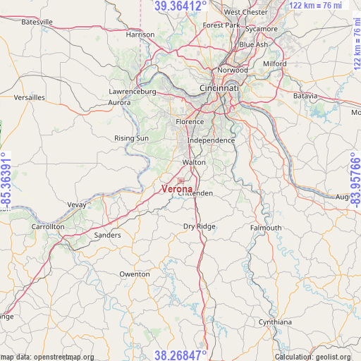
Verona GPS coordinates[2]
38° 49' 6.24" North, 84° 39' 38.808" West
| Map corner | latitude | longitude |
|---|---|---|
| Upper-left | 39.36412°, | -85.36391° |
| Center: | 38.8184°, | -84.66078° |
| Lower-right: | 38.26847°, | -83.95766° |
| Map W x H: | 121.8×121.8 km | = 75.7×75.7mi |
| max Lat: | 71.29058° ⇑56.4% North |
| Verona: | 38.8184° |
| min Lat: | ⇓43.6% South 19.06759° |
| min Long | Verona | max Long |
| -171.73463° | -84.66078° | -66.98998° |
| W 56.7%⇐ | ⇒43.3% E |
Elevation
Elevation of Verona is 272 m = 892 ft, and this is 22.8 m = 75 ft below average elevation for this country.
| Max E: |
3189 m = 10463 ft | 32.8% |
| Avg. | 294.8 m = 967 ft | |
| Verona | 272 m = 892 ft | |
Min E: |
-60 m = -197 ft | 67.2% |
See also: United States elevation on elevation.city.
Geographical zone
Verona is located in North temperate zone (between Tropic of Cancer and the Arctic Circle). Distance of this Northern Tropic circle is 1710.3 km =1062.7 mi to South.| Distance of | km | miles | from Verona |
|---|---|---|---|
| North Pole | 5690.9 | 3536.2 | to North |
| Arctic Circle | 3085 | 1916.9 | to North |
| Tropic Cancer | 1710.3 | 1062.7 | to South |
| Equator | 4316.2 | 2682 | to South |


Nearby cities:
15 places around Verona: (largest is in red/bold)
• Burlington
23.9 km =14.9 mi,  346°
346°
• Crittenden
6.2 km =3.9 mi,  129°
129°
• Dry Ridge
16.4 km =10.2 mi,  157°
157°
• Edgewood
23.3 km =14.5 mi,  17°
17°
• Elsmere
22.1 km =13.7 mi,  12°
12°
• Erlanger
22.7 km =14.1 mi, 13°
• Florence
20.3 km =12.6 mi, 8°
• Independence
17.2 km =10.7 mi,  36°
36°
• Oakbrook
20.3 km =12.6 mi, 354°
• Rising Sun
22.2 km =13.8 mi,  311°
311°
• Ryland Heights
23.1 km =14.4 mi,  47°
47°
• Union
14.3 km =8.9 mi, 353°
• Walton
7.7 km =4.8 mi,  34°
34°
• Warsaw
21.2 km =13.2 mi,  259°
259°
• Williamstown
21.9 km =13.6 mi, 156°
Sources, notices
• [Note1] Compared only with cities in United States existing in our database
• [Src1] Map data: © OpenStreetMap contributors (CC-BY-SA)
• [Src2] Other city data from geonames.org with taken over terms of usage.
• [Src3] Geographical zone / Annual Mean Temperature by Robert A. Rohde @ Wikipedia
