Covington geodata
Covington (Kentucky) is a populated place; located in United States in America/New_York (GMT-4) time zone. With population of 40,997 people, there are 1174 cities with bigger population in this country. Compared to other cities in United States, 54.1% of cities are located further ↑North; 57.4% of cities are located further ←West and 59.5% of cities have higher elevation than Covington. Note1


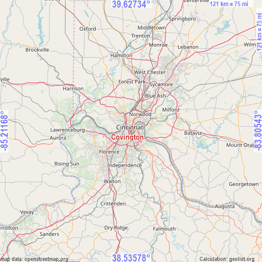
Covington GPS coordinates[2]
39° 5' 1.212" North, 84° 30' 30.78" West
| Map corner | latitude | longitude |
|---|---|---|
| Upper-left | 39.62734°, | -85.21168° |
| Center: | 39.08367°, | -84.50855° |
| Lower-right: | 38.53578°, | -83.80543° |
| Map W x H: | 121.4×121.4 km | = 75.4×75.4mi |
| max Lat: | 71.29058° ⇑54.1% North |
| Covington: | 39.08367° |
| min Lat: | ⇓45.9% South 19.06759° |
| min Long | Covington | max Long |
| -171.73463° | -84.50855° | -66.98998° |
| W 57.4%⇐ | ⇒42.6% E |
Elevation
Elevation of Covington is 157 m = 515 ft, and this is 137.8 m = 452 ft below average elevation for this country.
| Max E: |
3189 m = 10463 ft | 59.5% |
| Avg. | 294.8 m = 967 ft | |
| Covington | 157 m = 515 ft | |
Min E: |
-60 m = -197 ft | 40.5% |
See also: Covington elevation on elevation.city.
Geographical zone
Covington is located in North temperate zone (between Tropic of Cancer and the Arctic Circle). Distance of this Northern Tropic circle is 1739.8 km =1081.1 mi to South.| Distance of | km | miles | from Covington |
|---|---|---|---|
| North Pole | 5661.4 | 3517.8 | to North |
| Arctic Circle | 3055.5 | 1898.6 | to North |
| Tropic Cancer | 1739.8 | 1081.1 | to South |
| Equator | 4345.7 | 2700.3 | to South |


Nearby cities:
15 places around Covington: (largest is in red/bold)
• Bellevue
3.6 km =2.2 mi,  45°
45°
• Bromley
4.5 km =2.8 mi,  267°
267°
• Cincinnati
4.9 km =3 mi,  354°
354°
• Crescent Springs
7.3 km =4.5 mi,  240°
240°
• Dayton
4.5 km =2.8 mi,  43°
43°
• Fort Mitchell
4.3 km =2.7 mi,  231°
231°
• Fort Thomas
5.4 km =3.4 mi,  100°
100°
• Fort Wright
4.2 km =2.6 mi,  211°
211°
• Highland Heights
7.5 km =4.7 mi,  138°
138°
• Lakeside Park
7.5 km =4.7 mi,  224°
224°
• Ludlow
3.5 km =2.2 mi,  286°
286°
• Newport
1.4 km =0.9 mi, 51°
• Park Hills
2.5 km =1.6 mi, 236°
• Southgate
3.4 km =2.1 mi,  112°
112°
• Wilder
3.6 km =2.2 mi,  148°
148°
Sources, notices
• [Note1] Compared only with cities in United States existing in our database
• [Src1] Map data: © OpenStreetMap contributors (CC-BY-SA)
• [Src2] Other city data from geonames.org with taken over terms of usage.
• [Src3] Geographical zone / Annual Mean Temperature by Robert A. Rohde @ Wikipedia
