Dayton geodata
Dayton (Kentucky) is a populated place; located in United States in America/New_York (GMT-4) time zone. With population of 5,433 people, there are 6816 cities with bigger population in this country. Compared to other cities in United States, 53.8% of cities are located further ↑North; 57.5% of cities are located further ←West and 59.1% of cities have higher elevation than Dayton. Note1


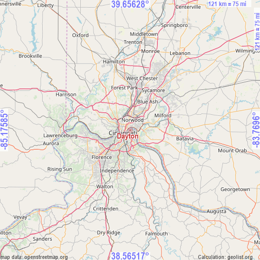
Dayton GPS coordinates[2]
39° 6' 46.224" North, 84° 28' 21.792" West
| Map corner | latitude | longitude |
|---|---|---|
| Upper-left | 39.65628°, | -85.17585° |
| Center: | 39.11284°, | -84.47272° |
| Lower-right: | 38.56517°, | -83.7696° |
| Map W x H: | 121.3×121.3 km | = 75.4×75.4mi |
| max Lat: | 71.29058° ⇑53.8% North |
| Dayton: | 39.11284° |
| min Lat: | ⇓46.2% South 19.06759° |
| min Long | Dayton | max Long |
| -171.73463° | -84.47272° | -66.98998° |
| W 57.5%⇐ | ⇒42.5% E |
Elevation
Elevation of Dayton is 159 m = 522 ft, and this is 135.8 m = 446 ft below average elevation for this country.
| Max E: |
3189 m = 10463 ft | 59.1% |
| Avg. | 294.8 m = 967 ft | |
| Dayton | 159 m = 522 ft | |
Min E: |
-60 m = -197 ft | 40.9% |
See also: United States elevation on elevation.city.
Geographical zone
Dayton is located in North temperate zone (between Tropic of Cancer and the Arctic Circle). Distance of this Northern Tropic circle is 1743 km =1083 mi to South.| Distance of | km | miles | from Dayton |
|---|---|---|---|
| North Pole | 5658.1 | 3515.8 | to North |
| Arctic Circle | 3052.2 | 1896.5 | to North |
| Tropic Cancer | 1743 | 1083 | to South |
| Equator | 4348.9 | 2702.3 | to South |


Nearby cities:
15 places around Dayton: (largest is in red/bold)
• Bellevue
0.9 km =0.6 mi,  216°
216°
• Bromley
8.3 km =5.2 mi,  245°
245°
• Cincinnati
3.9 km =2.4 mi,  293°
293°
• Covington
4.5 km =2.8 mi, 223°
• Elmwood Place
8.4 km =5.2 mi,  350°
350°
• Fairfax
7.7 km =4.8 mi,  62°
62°
• Fort Thomas
4.7 km =2.9 mi,  152°
152°
• Ludlow
6.8 km =4.2 mi, 250°
• Newport
3.1 km =1.9 mi, 219°
• Norwood
4.9 km =3 mi,  13°
13°
• Park Hills
6.9 km =4.3 mi,  228°
228°
• Saint Bernard
6.4 km =4 mi,  339°
339°
• Southgate
4.5 km =2.8 mi,  180°
180°
• Turpin Hills
8 km =5 mi,  92°
92°
• Wilder
6.4 km =4 mi,  191°
191°
Sources, notices
• [Note1] Compared only with cities in United States existing in our database
• [Src1] Map data: © OpenStreetMap contributors (CC-BY-SA)
• [Src2] Other city data from geonames.org with taken over terms of usage.
• [Src3] Geographical zone / Annual Mean Temperature by Robert A. Rohde @ Wikipedia
