Cincinnati geodata
Cincinnati (Ohio) is a seat of a second-order administrative division; located in United States in America/New_York (GMT-4) time zone. With population of 296,943 people, there are 71 cities with bigger population in this country. Compared to other cities in United States, 53.7% of cities are located further ↑North; 57.4% of cities are located further ←West and 66.1% of cities have lower elevation than Cincinnati. Note1


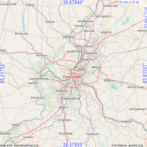
Cincinnati GPS coordinates[2]
39° 7' 37.596" North, 84° 30' 51.804" West
| Map corner | latitude | longitude |
|---|---|---|
| Upper-left | 39.67044°, | -85.21752° |
| Center: | 39.12711°, | -84.51439° |
| Lower-right: | 38.57955°, | -83.81127° |
| Map W x H: | 121.3×121.3 km | = 75.4×75.4mi |
| max Lat: | 71.29058° ⇑53.7% North |
| Cincinnati: | 39.12711° |
| min Lat: | ⇓46.3% South 19.06759° |
| min Long | Cincinnati | max Long |
| -171.73463° | -84.51439° | -66.98998° |
| W 57.4%⇐ | ⇒42.6% E |
Elevation
Elevation of Cincinnati is 267 m = 876 ft, and this is 27.8 m = 91 ft below average elevation for this country.
| Max E: |
3189 m = 10463 ft | 33.9% |
| Avg. | 294.8 m = 967 ft | |
| Cincinnati | 267 m = 876 ft | |
Min E: |
-60 m = -197 ft | 66.1% |
See also: Cincinnati elevation on elevation.city.
Geographical zone
Cincinnati is located in North temperate zone (between Tropic of Cancer and the Arctic Circle). Distance of this Northern Tropic circle is 1744.6 km =1084 mi to South.| Distance of | km | miles | from Cincinnati |
|---|---|---|---|
| North Pole | 5656.5 | 3514.8 | to North |
| Arctic Circle | 3050.6 | 1895.6 | to North |
| Tropic Cancer | 1744.6 | 1084 | to South |
| Equator | 4350.5 | 2703.3 | to South |


Nearby cities:
15 places around Cincinnati: (largest is in red/bold)
• Bellevue
3.8 km =2.4 mi,  126°
126°
• Bromley
6.4 km =4 mi,  218°
218°
• Covedale
8 km =5 mi,  265°
265°
• Covington
4.9 km =3 mi,  174°
174°
• Dayton
3.9 km =2.4 mi,  113°
113°
• Elmwood Place
7.1 km =4.4 mi,  18°
18°
• Fort Mitchell
8 km =5 mi,  200°
200°
• Fort Thomas
8.2 km =5.1 mi, 134°
• Ludlow
4.8 km =3 mi, 216°
• Newport
4.3 km =2.7 mi,  157°
157°
• Norwood
5.7 km =3.5 mi,  56°
56°
• Park Hills
6.4 km =4 mi,  193°
193°
• Saint Bernard
4.6 km =2.9 mi, 17°
• Southgate
7.1 km =4.4 mi,  149°
149°
• Wilder
8.2 km =5.1 mi, 163°
Sources, notices
• [Note1] Compared only with cities in United States existing in our database
• [Src1] Map data: © OpenStreetMap contributors (CC-BY-SA)
• [Src2] Other city data from geonames.org with taken over terms of usage.
• [Src3] Geographical zone / Annual Mean Temperature by Robert A. Rohde @ Wikipedia
