Lewisport geodata
Lewisport (Kentucky) is a populated place; located in United States in America/Chicago (GMT-5) time zone. With population of 1,698 people, there are 12916 cities with bigger population in this country. Compared to other cities in United States, 62% of cities are located further ↑North; 50.5% of cities are located further ←West and 66.6% of cities have higher elevation than Lewisport. Note1


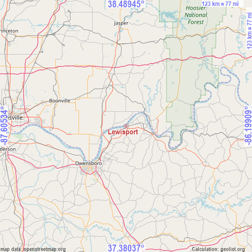
Lewisport GPS coordinates[2]
37° 56' 13.2" North, 86° 54' 7.956" West
| Map corner | latitude | longitude |
|---|---|---|
| Upper-left | 38.48945°, | -87.60534° |
| Center: | 37.937°, | -86.90221° |
| Lower-right: | 37.38037°, | -86.19909° |
| Map W x H: | 123.3×123.3 km | = 76.6×76.6mi |
| max Lat: | 71.29058° ⇑62% North |
| Lewisport: | 37.937° |
| min Lat: | ⇓38% South 19.06759° |
| min Long | Lewisport | max Long |
| -171.73463° | -86.90221° | -66.98998° |
| W 50.5%⇐ | ⇒49.5% E |
Elevation
Elevation of Lewisport is 120 m = 394 ft, and this is 174.8 m = 573 ft below average elevation for this country.
| Max E: |
3189 m = 10463 ft | 66.6% |
| Avg. | 294.8 m = 967 ft | |
| Lewisport | 120 m = 394 ft | |
Min E: |
-60 m = -197 ft | 33.4% |
See also: United States elevation on elevation.city.
Geographical zone
Lewisport is located in North temperate zone (between Tropic of Cancer and the Arctic Circle). Distance of this Northern Tropic circle is 1612.3 km =1001.8 mi to South.| Distance of | km | miles | from Lewisport |
|---|---|---|---|
| North Pole | 5788.9 | 3597.1 | to North |
| Arctic Circle | 3183 | 1977.8 | to North |
| Tropic Cancer | 1612.3 | 1001.8 | to South |
| Equator | 4218.2 | 2621.1 | to South |


Nearby cities:
15 places around Lewisport: (largest is in red/bold)
• Cannelton
14.1 km =8.8 mi,  101°
101°
• Cloverport
26.3 km =16.3 mi,  115°
115°
• Dale
26.9 km =16.7 mi,  343°
343°
• Ferdinand
32.1 km =19.9 mi,  6°
6°
• Grandview
6.9 km =4.3 mi,  266°
266°
• Hatfield
28.5 km =17.7 mi,  262°
262°
• Hawesville
13.6 km =8.5 mi,  107°
107°
• Knottsville
18.4 km =11.4 mi,  180°
180°
• Masonville
31.4 km =19.5 mi,  201°
201°
• Owensboro
25.9 km =16.1 mi,  225°
225°
• Rockport
14.2 km =8.8 mi,  245°
245°
• Saint Meinrad
27.3 km =17 mi,  17°
17°
• Santa Claus
20.4 km =12.7 mi,  357°
357°
• Tell City
11.9 km =7.4 mi,  82°
82°
• Whitesville
28.4 km =17.6 mi,  174°
174°
Sources, notices
• [Note1] Compared only with cities in United States existing in our database
• [Src1] Map data: © OpenStreetMap contributors (CC-BY-SA)
• [Src2] Other city data from geonames.org with taken over terms of usage.
• [Src3] Geographical zone / Annual Mean Temperature by Robert A. Rohde @ Wikipedia
