Hatfield geodata
Hatfield (Indiana) is a populated place; located in United States in America/Chicago (GMT-5) time zone. With population of 813 people, there are 17692 cities with bigger population in this country. Compared to other cities in United States, 62.2% of cities are located further ↑North; 50.2% of cities are located further →East and 67.1% of cities have higher elevation than Hatfield. Note1


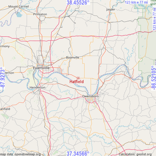
Hatfield GPS coordinates[2]
37° 54' 9.18" North, 87° 13' 27.012" West
| Map corner | latitude | longitude |
|---|---|---|
| Upper-left | 38.45526°, | -87.9273° |
| Center: | 37.90255°, | -87.22417° |
| Lower-right: | 37.34566°, | -86.52105° |
| Map W x H: | 123.4×123.4 km | = 76.7×76.7mi |
| max Lat: | 71.29058° ⇑62.2% North |
| Hatfield: | 37.90255° |
| min Lat: | ⇓37.8% South 19.06759° |
| min Long | Hatfield | max Long |
| -171.73463° | -87.22417° | -66.98998° |
| W 49.8%⇐ | ⇒50.2% E |
Elevation
Elevation of Hatfield is 117 m = 384 ft, and this is 177.8 m = 583 ft below average elevation for this country.
| Max E: |
3189 m = 10463 ft | 67.1% |
| Avg. | 294.8 m = 967 ft | |
| Hatfield | 117 m = 384 ft | |
Min E: |
-60 m = -197 ft | 32.9% |
See also: United States elevation on elevation.city.
Geographical zone
Hatfield is located in North temperate zone (between Tropic of Cancer and the Arctic Circle). Distance of this Northern Tropic circle is 1608.4 km =999.4 mi to South.| Distance of | km | miles | from Hatfield |
|---|---|---|---|
| North Pole | 5792.7 | 3599.4 | to North |
| Arctic Circle | 3186.8 | 1980.2 | to North |
| Tropic Cancer | 1608.4 | 999.4 | to South |
| Equator | 4214.4 | 2618.7 | to South |


Nearby cities:
15 places around Hatfield: (largest is in red/bold)
• Boonville
16.9 km =10.5 mi,  344°
344°
• Chandler
20 km =12.4 mi,  320°
320°
• Elberfeld
34.7 km =21.6 mi,  325°
325°
• Evansville
30.2 km =18.8 mi,  285°
285°
• Grandview
21.6 km =13.4 mi,  80°
80°
• Henderson
32.9 km =20.4 mi,  257°
257°
• Highland
34.2 km =21.3 mi,  296°
296°
• Knottsville
31.6 km =19.6 mi,  117°
117°
• Lewisport
28.5 km =17.7 mi, 82°
• Lynnville
33.3 km =20.7 mi,  348°
348°
• Masonville
30.3 km =18.8 mi,  146°
146°
• Melody Hill
29 km =18 mi, 298°
• Newburgh
16.6 km =10.3 mi, 286°
• Owensboro
17.3 km =10.7 mi, 145°
• Rockport
15.5 km =9.6 mi,  98°
98°
Sources, notices
• [Note1] Compared only with cities in United States existing in our database
• [Src1] Map data: © OpenStreetMap contributors (CC-BY-SA)
• [Src2] Other city data from geonames.org with taken over terms of usage.
• [Src3] Geographical zone / Annual Mean Temperature by Robert A. Rohde @ Wikipedia
