Owensboro geodata
Owensboro (Kentucky) is a seat of a second-order administrative division; located in United States in America/Chicago (GMT-5) time zone. With population of 59,042 people, there are 766 cities with bigger population in this country. Compared to other cities in United States, 62.8% of cities are located further ↑North; 50% of cities are located further ←West and 65.6% of cities have higher elevation than Owensboro. Note1


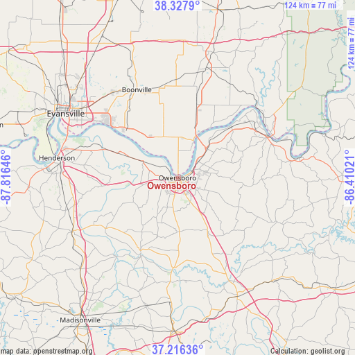
Owensboro GPS coordinates[2]
37° 46' 27.192" North, 87° 6' 47.988" West
| Map corner | latitude | longitude |
|---|---|---|
| Upper-left | 38.3279°, | -87.81646° |
| Center: | 37.77422°, | -87.11333° |
| Lower-right: | 37.21636°, | -86.41021° |
| Map W x H: | 123.6×123.6 km | = 76.8×76.8mi |
| max Lat: | 71.29058° ⇑62.8% North |
| Owensboro: | 37.77422° |
| min Lat: | ⇓37.2% South 19.06759° |
| min Long | Owensboro | max Long |
| -171.73463° | -87.11333° | -66.98998° |
| W 50%⇐ | ⇒50% E |
Elevation
Elevation of Owensboro is 125 m = 410 ft, and this is 169.8 m = 557 ft below average elevation for this country.
| Max E: |
3189 m = 10463 ft | 65.6% |
| Avg. | 294.8 m = 967 ft | |
| Owensboro | 125 m = 410 ft | |
Min E: |
-60 m = -197 ft | 34.4% |
See also: Owensboro elevation on elevation.city.
Geographical zone
Owensboro is located in North temperate zone (between Tropic of Cancer and the Arctic Circle). Distance of this Northern Tropic circle is 1594.2 km =990.6 mi to South.| Distance of | km | miles | from Owensboro |
|---|---|---|---|
| North Pole | 5807 | 3608.3 | to North |
| Arctic Circle | 3201.1 | 1989.1 | to North |
| Tropic Cancer | 1594.2 | 990.6 | to South |
| Equator | 4200.1 | 2609.8 | to South |


Nearby cities:
15 places around Owensboro: (largest is in red/bold)
• Boonville
33.7 km =20.9 mi,  335°
335°
• Calhoun
29.1 km =18.1 mi,  206°
206°
• Cannelton
35.8 km =22.2 mi,  64°
64°
• Chandler
37.2 km =23.1 mi,  323°
323°
• Grandview
21.2 km =13.2 mi,  33°
33°
• Hatfield
17.3 km =10.7 mi,  325°
325°
• Hawesville
34.4 km =21.4 mi,  66°
66°
• Knottsville
18.4 km =11.4 mi,  90°
90°
• Lewisport
25.9 km =16.1 mi,  45°
45°
• Livermore
31.3 km =19.4 mi,  183°
183°
• Masonville
13 km =8.1 mi,  147°
147°
• Newburgh
31.9 km =19.8 mi,  306°
306°
• Rockport
13.3 km =8.3 mi,  24°
24°
• Tell City
36.2 km =22.5 mi, 56°
• Whitesville
23.6 km =14.7 mi,  115°
115°
Sources, notices
• [Note1] Compared only with cities in United States existing in our database
• [Src1] Map data: © OpenStreetMap contributors (CC-BY-SA)
• [Src2] Other city data from geonames.org with taken over terms of usage.
• [Src3] Geographical zone / Annual Mean Temperature by Robert A. Rohde @ Wikipedia
