Russell geodata
Russell (Kentucky) is a populated place; located in United States in America/New_York (GMT-4) time zone. With population of 3,260 people, there are 9211 cities with bigger population in this country. Compared to other cities in United States, 58.7% of cities are located further ↑North; 63% of cities are located further ←West and 51.5% of cities have lower elevation than Russell. Note1


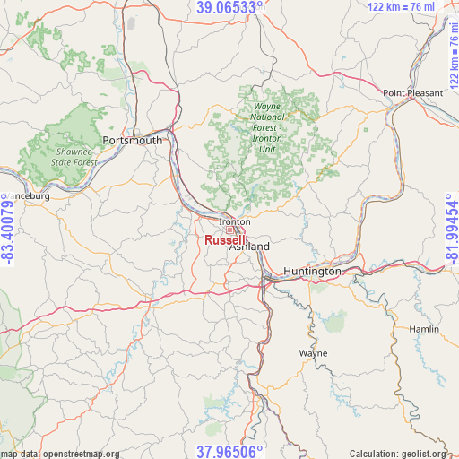
Russell GPS coordinates[2]
38° 31' 2.28" North, 82° 41' 51.576" West
| Map corner | latitude | longitude |
|---|---|---|
| Upper-left | 39.06533°, | -83.40079° |
| Center: | 38.5173°, | -82.69766° |
| Lower-right: | 37.96506°, | -81.99454° |
| Map W x H: | 122.3×122.3 km | = 76×76mi |
| max Lat: | 71.29058° ⇑58.7% North |
| Russell: | 38.5173° |
| min Lat: | ⇓41.3% South 19.06759° |
| min Long | Russell | max Long |
| -171.73463° | -82.69766° | -66.98998° |
| W 63%⇐ | ⇒37% E |
Elevation
Elevation of Russell is 204 m = 669 ft, and this is 90.8 m = 298 ft below average elevation for this country.
| Max E: |
3189 m = 10463 ft | 48.5% |
| Avg. | 294.8 m = 967 ft | |
| Russell | 204 m = 669 ft | |
Min E: |
-60 m = -197 ft | 51.5% |
See also: United States elevation on elevation.city.
Geographical zone
Russell is located in North temperate zone (between Tropic of Cancer and the Arctic Circle). Distance of this Northern Tropic circle is 1676.8 km =1041.9 mi to South.| Distance of | km | miles | from Russell |
|---|---|---|---|
| North Pole | 5724.3 | 3556.9 | to North |
| Arctic Circle | 3118.5 | 1937.7 | to North |
| Tropic Cancer | 1676.8 | 1041.9 | to South |
| Equator | 4282.7 | 2661.1 | to South |


Nearby cities:
15 places around Russell: (largest is in red/bold)
• Ashland
6.8 km =4.2 mi,  129°
129°
• Bellefonte
2.8 km =1.7 mi,  166°
166°
• Cannonsburg
14.3 km =8.9 mi,  181°
181°
• Catlettsburg
15.1 km =9.4 mi,  145°
145°
• Coal Grove
4.7 km =2.9 mi,  109°
109°
• Flatwoods
1.8 km =1.1 mi,  289°
289°
• Greenup
13.1 km =8.1 mi,  298°
298°
• Ironton
2.5 km =1.6 mi,  30°
30°
• Ironville
6.8 km =4.2 mi, 176°
• Meads
11.7 km =7.3 mi, 184°
• Raceland
3.7 km =2.3 mi,  313°
313°
• South Point
14.7 km =9.1 mi,  138°
138°
• Westwood
4.5 km =2.8 mi, 147°
• Worthington
4.2 km =2.6 mi,  326°
326°
• Wurtland
7.9 km =4.9 mi, 297°
Sources, notices
• [Note1] Compared only with cities in United States existing in our database
• [Src1] Map data: © OpenStreetMap contributors (CC-BY-SA)
• [Src2] Other city data from geonames.org with taken over terms of usage.
• [Src3] Geographical zone / Annual Mean Temperature by Robert A. Rohde @ Wikipedia
