South Point geodata
South Point (Ohio) is a populated place; located in United States in America/New_York (GMT-4) time zone. With population of 3,924 people, there are 8300 cities with bigger population in this country. Compared to other cities in United States, 59.2% of cities are located further ↑North; 63.4% of cities are located further ←West and 57.5% of cities have higher elevation than South Point. Note1


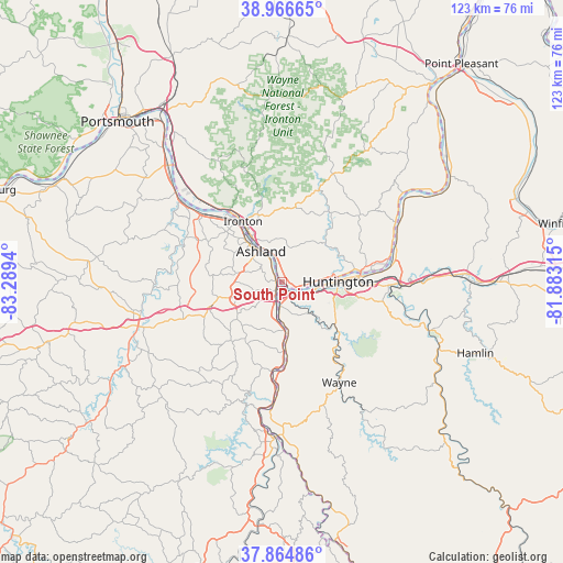
South Point GPS coordinates[2]
38° 25' 4.296" North, 82° 35' 10.572" West
| Map corner | latitude | longitude |
|---|---|---|
| Upper-left | 38.96665°, | -83.2894° |
| Center: | 38.41786°, | -82.58627° |
| Lower-right: | 37.86486°, | -81.88315° |
| Map W x H: | 122.5×122.5 km | = 76.1×76.1mi |
| max Lat: | 71.29058° ⇑59.2% North |
| South Point: | 38.41786° |
| min Lat: | ⇓40.8% South 19.06759° |
| min Long | South Point | max Long |
| -171.73463° | -82.58627° | -66.98998° |
| W 63.4%⇐ | ⇒36.6% E |
Elevation
Elevation of South Point is 168 m = 551 ft, and this is 126.8 m = 416 ft below average elevation for this country.
| Max E: |
3189 m = 10463 ft | 57.5% |
| Avg. | 294.8 m = 967 ft | |
| South Point | 168 m = 551 ft | |
Min E: |
-60 m = -197 ft | 42.5% |
See also: United States elevation on elevation.city.
Geographical zone
South Point is located in North temperate zone (between Tropic of Cancer and the Arctic Circle). Distance of this Northern Tropic circle is 1665.7 km =1035 mi to South.| Distance of | km | miles | from South Point |
|---|---|---|---|
| North Pole | 5735.4 | 3563.8 | to North |
| Arctic Circle | 3129.5 | 1944.6 | to North |
| Tropic Cancer | 1665.7 | 1035 | to South |
| Equator | 4271.7 | 2654.3 | to South |


Nearby cities:
15 places around South Point: (largest is in red/bold)
• Ashland
8.1 km =5 mi,  326°
326°
• Bellefonte
12.3 km =7.6 mi,  312°
312°
• Burlington
4.6 km =2.9 mi,  104°
104°
• Cannonsburg
10.6 km =6.6 mi,  252°
252°
• Catlettsburg
1.9 km =1.2 mi,  220°
220°
• Ceredo
3.4 km =2.1 mi,  134°
134°
• Chesapeake
11.3 km =7 mi,  84°
84°
• Coal Grove
10.9 km =6.8 mi, 330°
• Huntington
12.3 km =7.6 mi,  89°
89°
• Ironton
15.7 km =9.8 mi, 327°
• Ironville
10.2 km =6.3 mi,  294°
294°
• Kenova
2.2 km =1.4 mi,  161°
161°
• Meads
10.7 km =6.6 mi,  266°
266°
• Russell
14.7 km =9.1 mi,  318°
318°
• Westwood
10.3 km =6.4 mi, 314°
Sources, notices
• [Note1] Compared only with cities in United States existing in our database
• [Src1] Map data: © OpenStreetMap contributors (CC-BY-SA)
• [Src2] Other city data from geonames.org with taken over terms of usage.
• [Src3] Geographical zone / Annual Mean Temperature by Robert A. Rohde @ Wikipedia
