Taylorsville geodata
Taylorsville (Kentucky) is a seat of a second-order administrative division; located in United States in America/New_York (GMT-4) time zone. With population of 1,028 people, there are 16094 cities with bigger population in this country. Compared to other cities in United States, 61.4% of cities are located further ↑North; 55% of cities are located further ←West and 61.1% of cities have higher elevation than Taylorsville. Note1


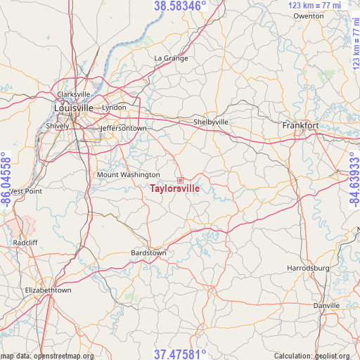
Taylorsville GPS coordinates[2]
38° 1' 54.228" North, 85° 20' 32.82" West
| Map corner | latitude | longitude |
|---|---|---|
| Upper-left | 38.58346°, | -86.04558° |
| Center: | 38.03173°, | -85.34245° |
| Lower-right: | 37.47581°, | -84.63933° |
| Map W x H: | 123.2×123.2 km | = 76.6×76.6mi |
| max Lat: | 71.29058° ⇑61.4% North |
| Taylorsville: | 38.03173° |
| min Lat: | ⇓38.6% South 19.06759° |
| min Long | Taylorsville | max Long |
| -171.73463° | -85.34245° | -66.98998° |
| W 55%⇐ | ⇒45% E |
Elevation
Elevation of Taylorsville is 149 m = 489 ft, and this is 145.8 m = 478 ft below average elevation for this country.
| Max E: |
3189 m = 10463 ft | 61.1% |
| Avg. | 294.8 m = 967 ft | |
| Taylorsville | 149 m = 489 ft | |
Min E: |
-60 m = -197 ft | 38.9% |
See also: United States elevation on elevation.city.
Geographical zone
Taylorsville is located in North temperate zone (between Tropic of Cancer and the Arctic Circle). Distance of this Northern Tropic circle is 1622.8 km =1008.4 mi to South.| Distance of | km | miles | from Taylorsville |
|---|---|---|---|
| North Pole | 5778.3 | 3590.5 | to North |
| Arctic Circle | 3172.4 | 1971.2 | to North |
| Tropic Cancer | 1622.8 | 1008.4 | to South |
| Equator | 4228.7 | 2627.6 | to South |


Nearby cities:
15 places around Taylorsville: (largest is in red/bold)
• Bardstown
27 km =16.8 mi,  203°
203°
• Bloomfield
13.7 km =8.5 mi,  170°
170°
• Douglass Hills
29.4 km =18.3 mi,  321°
321°
• Elk Creek
8 km =5 mi,  341°
341°
• Fern Creek
25.8 km =16 mi,  303°
303°
• Hebron Estates
28.4 km =17.6 mi,  273°
273°
• Highview
27.6 km =17.1 mi, 296°
• Hollow Creek
28.1 km =17.5 mi, 298°
• Jeffersontown
26.5 km =16.5 mi,  312°
312°
• Middletown
29.3 km =18.2 mi, 324°
• Mount Washington
17.9 km =11.1 mi,  276°
276°
• Pioneer Village
29.5 km =18.3 mi, 276°
• Shelbyville
22.6 km =14 mi,  27°
27°
• Simpsonville
21.2 km =13.2 mi,  356°
356°
• Woodland Hills
28.1 km =17.5 mi,  325°
325°
Sources, notices
• [Note1] Compared only with cities in United States existing in our database
• [Src1] Map data: © OpenStreetMap contributors (CC-BY-SA)
• [Src2] Other city data from geonames.org with taken over terms of usage.
• [Src3] Geographical zone / Annual Mean Temperature by Robert A. Rohde @ Wikipedia
