Stanford geodata
Stanford (Kentucky) is a seat of a second-order administrative division; located in United States in America/New_York (GMT-4) time zone. With population of 3,675 people, there are 8625 cities with bigger population in this country. Compared to other cities in United States, 64% of cities are located further ↑North; 56.7% of cities are located further ←West and 70.6% of cities have lower elevation than Stanford. Note1


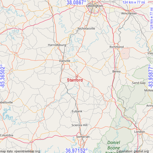
Stanford GPS coordinates[2]
37° 31' 52.284" North, 84° 39' 42.804" West
| Map corner | latitude | longitude |
|---|---|---|
| Upper-left | 38.0867°, | -85.36502° |
| Center: | 37.53119°, | -84.66189° |
| Lower-right: | 36.97152°, | -83.95877° |
| Map W x H: | 124×124 km | = 77.1×77.1mi |
| max Lat: | 71.29058° ⇑64% North |
| Stanford: | 37.53119° |
| min Lat: | ⇓36% South 19.06759° |
| min Long | Stanford | max Long |
| -171.73463° | -84.66189° | -66.98998° |
| W 56.7%⇐ | ⇒43.3% E |
Elevation
Elevation of Stanford is 289 m = 948 ft, and this is 5.8 m = 19 ft below average elevation for this country.
| Max E: |
3189 m = 10463 ft | 29.4% |
| Avg. | 294.8 m = 967 ft | |
| Stanford | 289 m = 948 ft | |
Min E: |
-60 m = -197 ft | 70.6% |
See also: United States elevation on elevation.city.
Geographical zone
Stanford is located in North temperate zone (between Tropic of Cancer and the Arctic Circle). Distance of this Northern Tropic circle is 1567.2 km =973.8 mi to South.| Distance of | km | miles | from Stanford |
|---|---|---|---|
| North Pole | 5834 | 3625.1 | to North |
| Arctic Circle | 3228.1 | 2005.8 | to North |
| Tropic Cancer | 1567.2 | 973.8 | to South |
| Equator | 4173.1 | 2593 | to South |


Nearby cities:
15 places around Stanford: (largest is in red/bold)
• Berea
32.5 km =20.2 mi,  82°
82°
• Brodhead
26 km =16.2 mi,  122°
122°
• Burgin
26.4 km =16.4 mi,  339°
339°
• Crab Orchard
15.6 km =9.7 mi, 118°
• Danville
16 km =9.9 mi,  322°
322°
• Harrodsburg
30.3 km =18.8 mi,  328°
328°
• Jackson
37.5 km =23.3 mi, 330°
• Junction City
13.2 km =8.2 mi,  297°
297°
• Lancaster
12.3 km =7.6 mi,  36°
36°
• Liberty
34.1 km =21.2 mi,  226°
226°
• Mount Vernon
34.6 km =21.5 mi, 124°
• Nicholasville
39.6 km =24.6 mi,  11°
11°
• Perryville
28.8 km =17.9 mi, 297°
• Science Hill
39.4 km =24.5 mi,  176°
176°
• Wilmore
36.8 km =22.9 mi,  0°
0°
Sources, notices
• [Note1] Compared only with cities in United States existing in our database
• [Src1] Map data: © OpenStreetMap contributors (CC-BY-SA)
• [Src2] Other city data from geonames.org with taken over terms of usage.
• [Src3] Geographical zone / Annual Mean Temperature by Robert A. Rohde @ Wikipedia
