Jackson geodata
Jackson (Kentucky) is a populated place; located in United States in America/New_York (GMT-4) time zone. With population of 2,356 people, there are 10957 cities with bigger population in this country. Compared to other cities in United States, 62.5% of cities are located further ↑North; 56.2% of cities are located further ←West and 65% of cities have lower elevation than Jackson. Note1


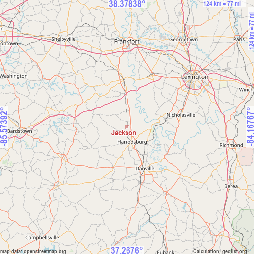
Jackson GPS coordinates[2]
37° 49' 30.288" North, 84° 52' 14.844" West
| Map corner | latitude | longitude |
|---|---|---|
| Upper-left | 38.37838°, | -85.57392° |
| Center: | 37.82508°, | -84.87079° |
| Lower-right: | 37.2676°, | -84.16767° |
| Map W x H: | 123.5×123.5 km | = 76.7×76.7mi |
| max Lat: | 71.29058° ⇑62.5% North |
| Jackson: | 37.82508° |
| min Lat: | ⇓37.5% South 19.06759° |
| min Long | Jackson | max Long |
| -171.73463° | -84.87079° | -66.98998° |
| W 56.2%⇐ | ⇒43.8% E |
Elevation
Elevation of Jackson is 262 m = 860 ft, and this is 32.8 m = 108 ft below average elevation for this country.
| Max E: |
3189 m = 10463 ft | 35% |
| Avg. | 294.8 m = 967 ft | |
| Jackson | 262 m = 860 ft | |
Min E: |
-60 m = -197 ft | 65% |
See also: United States elevation on elevation.city.
Geographical zone
Jackson is located in North temperate zone (between Tropic of Cancer and the Arctic Circle). Distance of this Northern Tropic circle is 1599.8 km =994.1 mi to South.| Distance of | km | miles | from Jackson |
|---|---|---|---|
| North Pole | 5801.3 | 3604.8 | to North |
| Arctic Circle | 3195.4 | 1985.5 | to North |
| Tropic Cancer | 1599.8 | 994.1 | to South |
| Equator | 4205.8 | 2613.4 | to South |


Nearby cities:
15 places around Jackson: (largest is in red/bold)
• Burgin
12.1 km =7.5 mi,  131°
131°
• Danville
21.8 km =13.5 mi,  156°
156°
• Harrodsburg
7.4 km =4.6 mi, 160°
• Junction City
27.4 km =17 mi,  165°
165°
• Lancaster
34.4 km =21.4 mi, 131°
• Lawrenceburg
23.7 km =14.7 mi,  354°
354°
• Lexington
39 km =24.2 mi,  62°
62°
• Midway
39.8 km =24.7 mi,  24°
24°
• Monticello
33.7 km =20.9 mi, 56°
• Nicholasville
26.9 km =16.7 mi,  76°
76°
• Perryville
20.7 km =12.9 mi,  200°
200°
• Springfield
34.6 km =21.5 mi,  243°
243°
• Stanford
37.5 km =23.3 mi,  150°
150°
• Versailles
28.1 km =17.5 mi,  26°
26°
• Wilmore
18.8 km =11.7 mi, 77°
Sources, notices
• [Note1] Compared only with cities in United States existing in our database
• [Src1] Map data: © OpenStreetMap contributors (CC-BY-SA)
• [Src2] Other city data from geonames.org with taken over terms of usage.
• [Src3] Geographical zone / Annual Mean Temperature by Robert A. Rohde @ Wikipedia
