Brodhead geodata
Brodhead (Kentucky) is a populated place; located in United States in America/New_York (GMT-4) time zone. With population of 1,205 people, there are 15100 cities with bigger population in this country. Compared to other cities in United States, 64.4% of cities are located further ↑North; 57.7% of cities are located further ←West and 70.6% of cities have lower elevation than Brodhead. Note1


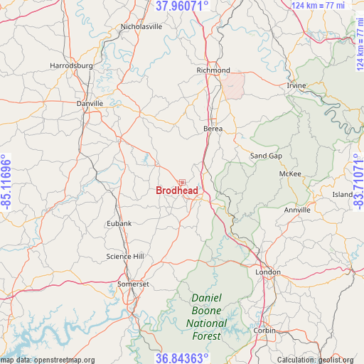
Brodhead GPS coordinates[2]
37° 24' 15.3" North, 84° 24' 49.788" West
| Map corner | latitude | longitude |
|---|---|---|
| Upper-left | 37.96071°, | -85.11696° |
| Center: | 37.40425°, | -84.41383° |
| Lower-right: | 36.84363°, | -83.71071° |
| Map W x H: | 124.2×124.2 km | = 77.2×77.2mi |
| max Lat: | 71.29058° ⇑64.4% North |
| Brodhead: | 37.40425° |
| min Lat: | ⇓35.6% South 19.06759° |
| min Long | Brodhead | max Long |
| -171.73463° | -84.41383° | -66.98998° |
| W 57.7%⇐ | ⇒42.3% E |
Elevation
Elevation of Brodhead is 289 m = 948 ft, and this is 5.8 m = 19 ft below average elevation for this country.
| Max E: |
3189 m = 10463 ft | 29.4% |
| Avg. | 294.8 m = 967 ft | |
| Brodhead | 289 m = 948 ft | |
Min E: |
-60 m = -197 ft | 70.6% |
See also: United States elevation on elevation.city.
Geographical zone
Brodhead is located in North temperate zone (between Tropic of Cancer and the Arctic Circle). Distance of this Northern Tropic circle is 1553 km =965 mi to South.| Distance of | km | miles | from Brodhead |
|---|---|---|---|
| North Pole | 5848.1 | 3633.8 | to North |
| Arctic Circle | 3242.2 | 2014.6 | to North |
| Tropic Cancer | 1553 | 965 | to South |
| Equator | 4159 | 2584.3 | to South |


Nearby cities:
15 places around Brodhead: (largest is in red/bold)
• Annville
40.3 km =25 mi,  103°
103°
• Berea
21 km =13 mi,  29°
29°
• Crab Orchard
10.6 km =6.6 mi,  309°
309°
• Danville
41.5 km =25.8 mi, 310°
• East Bernstadt
35.4 km =22 mi,  132°
132°
• Ferguson
41 km =25.5 mi,  203°
203°
• Junction City
39.2 km =24.4 mi,  301°
301°
• Lancaster
28 km =17.4 mi,  328°
328°
• London
42.3 km =26.3 mi,  136°
136°
• McKee
36.8 km =22.9 mi,  85°
85°
• Mount Vernon
8.6 km =5.3 mi, 131°
• Richmond
39.6 km =24.6 mi,  15°
15°
• Science Hill
32 km =19.9 mi,  217°
217°
• Somerset
38.6 km =24 mi,  205°
205°
• Stanford
26 km =16.2 mi, 302°
Sources, notices
• [Note1] Compared only with cities in United States existing in our database
• [Src1] Map data: © OpenStreetMap contributors (CC-BY-SA)
• [Src2] Other city data from geonames.org with taken over terms of usage.
• [Src3] Geographical zone / Annual Mean Temperature by Robert A. Rohde @ Wikipedia
