Wingo geodata
Wingo (Kentucky) is a populated place; located in United States in America/Chicago (GMT-5) time zone. With population of 640 people, there are 19272 cities with bigger population in this country. Compared to other cities in United States, 67.6% of cities are located further ↑North; 55.5% of cities are located further →East and 59.9% of cities have higher elevation than Wingo. Note1


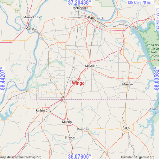
Wingo GPS coordinates[2]
36° 38' 32.208" North, 88° 44' 20.184" West
| Map corner | latitude | longitude |
|---|---|---|
| Upper-left | 37.20438°, | -89.44207° |
| Center: | 36.64228°, | -88.73894° |
| Lower-right: | 36.07605°, | -88.03582° |
| Map W x H: | 125.5×125.5 km | = 78×78mi |
| max Lat: | 71.29058° ⇑67.6% North |
| Wingo: | 36.64228° |
| min Lat: | ⇓32.4% South 19.06759° |
| min Long | Wingo | max Long |
| -171.73463° | -88.73894° | -66.98998° |
| W 44.5%⇐ | ⇒55.5% E |
Elevation
Elevation of Wingo is 155 m = 509 ft, and this is 139.8 m = 459 ft below average elevation for this country.
| Max E: |
3189 m = 10463 ft | 59.9% |
| Avg. | 294.8 m = 967 ft | |
| Wingo | 155 m = 509 ft | |
Min E: |
-60 m = -197 ft | 40.1% |
See also: United States elevation on elevation.city.
Geographical zone
Wingo is located in North temperate zone (between Tropic of Cancer and the Arctic Circle). Distance of this Northern Tropic circle is 1468.3 km =912.4 mi to South.| Distance of | km | miles | from Wingo |
|---|---|---|---|
| North Pole | 5932.8 | 3686.5 | to North |
| Arctic Circle | 3326.9 | 2067.2 | to North |
| Tropic Cancer | 1468.3 | 912.4 | to South |
| Equator | 4074.2 | 2531.6 | to South |


Nearby cities:
15 places around Wingo: (largest is in red/bold)
• Bardwell
35 km =21.7 mi,  316°
316°
• Benton
42.1 km =26.2 mi,  55°
55°
• Clinton
22.9 km =14.2 mi,  276°
276°
• Dresden
39.1 km =24.3 mi,  175°
175°
• Fulton
19.5 km =12.1 mi,  218°
218°
• Hardin
41.8 km =26 mi,  70°
70°
• Hickman
40.7 km =25.3 mi,  258°
258°
• Martin
34.7 km =21.6 mi,  196°
196°
• Massac
41.6 km =25.8 mi,  1°
1°
• Mayfield
14.3 km =8.9 mi,  39°
39°
• Murray
38 km =23.6 mi,  95°
95°
• Puryear
42.3 km =26.3 mi,  121°
121°
• South Fulton
19.9 km =12.4 mi, 217°
• Symsonia
36.5 km =22.7 mi,  32°
32°
• Union City
37.4 km =23.2 mi,  229°
229°
Sources, notices
• [Note1] Compared only with cities in United States existing in our database
• [Src1] Map data: © OpenStreetMap contributors (CC-BY-SA)
• [Src2] Other city data from geonames.org with taken over terms of usage.
• [Src3] Geographical zone / Annual Mean Temperature by Robert A. Rohde @ Wikipedia
