Hahnville geodata
Hahnville (Louisiana) is a seat of a second-order administrative division; located in United States in America/Chicago (GMT-5) time zone. With population of 3,344 people, there are 9070 cities with bigger population in this country. Compared to other cities in United States, 93.5% of cities are located further ↑North; 60.6% of cities are located further →East and 94.8% of cities have higher elevation than Hahnville. Note1


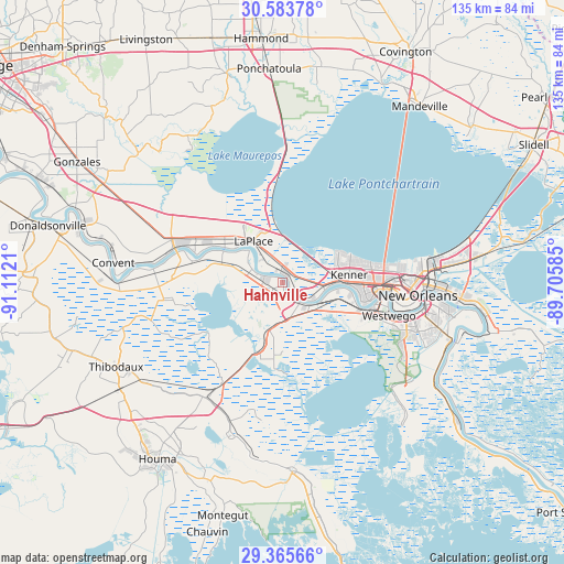
Hahnville GPS coordinates[2]
29° 58' 35.724" North, 90° 24' 32.292" West
| Map corner | latitude | longitude |
|---|---|---|
| Upper-left | 30.58378°, | -91.1121° |
| Center: | 29.97659°, | -90.40897° |
| Lower-right: | 29.36566°, | -89.70585° |
| Map W x H: | 135.4×135.4 km | = 84.1×84.1mi |
| max Lat: | 71.29058° ⇑93.5% North |
| Hahnville: | 29.97659° |
| min Lat: | ⇓6.5% South 19.06759° |
| min Long | Hahnville | max Long |
| -171.73463° | -90.40897° | -66.98998° |
| W 39.4%⇐ | ⇒60.6% E |
Elevation
Elevation of Hahnville is 9 m = 30 ft, and this is 285.8 m = 938 ft below average elevation for this country.
| Max E: |
3189 m = 10463 ft | 94.8% |
| Avg. | 294.8 m = 967 ft | |
| Hahnville | 9 m = 30 ft | |
Min E: |
-60 m = -197 ft | 5.2% |
See also: United States elevation on elevation.city.
Geographical zone
Hahnville is located in North temperate zone (between Tropic of Cancer and the Arctic Circle). Distance of this Northern Tropic circle is 727.2 km =451.9 mi to South.| Distance of | km | miles | from Hahnville |
|---|---|---|---|
| North Pole | 6674 | 4147 | to North |
| Arctic Circle | 4068.1 | 2527.8 | to North |
| Tropic Cancer | 727.2 | 451.9 | to South |
| Equator | 3333.1 | 2071.1 | to South |


Nearby cities:
15 places around Hahnville: (largest is in red/bold)
• Ama
11.2 km =7 mi,  104°
104°
• Boutte
8.5 km =5.3 mi,  166°
166°
• Destrehan
6.5 km =4 mi,  124°
124°
• Edgard
16.3 km =10.1 mi,  296°
296°
• Kenner
16.2 km =10.1 mi,  83°
83°
• Killona
7.8 km =4.8 mi,  294°
294°
• Laplace
12.2 km =7.6 mi,  325°
325°
• Luling
6.4 km =4 mi,  140°
140°
• Montegut
13.8 km =8.6 mi,  319°
319°
• Montz
6.7 km =4.2 mi, 300°
• New Sarpy
1.9 km =1.2 mi, 84°
• Norco
2.5 km =1.6 mi,  352°
352°
• Paradis
11 km =6.8 mi,  192°
192°
• Reserve
16.2 km =10.1 mi, 301°
• Saint Rose
8.9 km =5.5 mi,  111°
111°
Sources, notices
• [Note1] Compared only with cities in United States existing in our database
• [Src1] Map data: © OpenStreetMap contributors (CC-BY-SA)
• [Src2] Other city data from geonames.org with taken over terms of usage.
• [Src3] Geographical zone / Annual Mean Temperature by Robert A. Rohde @ Wikipedia
