Boutte geodata
Boutte (Louisiana) is a populated place; located in United States in America/Chicago (GMT-5) time zone. With population of 3,075 people, there are 9510 cities with bigger population in this country. Compared to other cities in United States, 93.7% of cities are located further ↑North; 60.5% of cities are located further →East and 96.6% of cities have higher elevation than Boutte. Note1


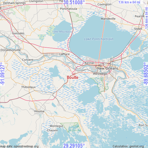
Boutte GPS coordinates[2]
29° 54' 8.748" North, 90° 23' 17.304" West
| Map corner | latitude | longitude |
|---|---|---|
| Upper-left | 30.51008°, | -91.09127° |
| Center: | 29.90243°, | -90.38814° |
| Lower-right: | 29.29105°, | -89.68502° |
| Map W x H: | 135.5×135.5 km | = 84.2×84.2mi |
| max Lat: | 71.29058° ⇑93.7% North |
| Boutte: | 29.90243° |
| min Lat: | ⇓6.3% South 19.06759° |
| min Long | Boutte | max Long |
| -171.73463° | -90.38814° | -66.98998° |
| W 39.5%⇐ | ⇒60.5% E |
Elevation
Elevation of Boutte is 7 m = 23 ft, and this is 287.8 m = 944 ft below average elevation for this country.
| Max E: |
3189 m = 10463 ft | 96.6% |
| Avg. | 294.8 m = 967 ft | |
| Boutte | 7 m = 23 ft | |
Min E: |
-60 m = -197 ft | 3.4% |
See also: United States elevation on elevation.city.
Geographical zone
Boutte is located in North temperate zone (between Tropic of Cancer and the Arctic Circle). Distance of this Northern Tropic circle is 718.9 km =446.7 mi to South.| Distance of | km | miles | from Boutte |
|---|---|---|---|
| North Pole | 6682.2 | 4152.1 | to North |
| Arctic Circle | 4076.3 | 2532.9 | to North |
| Tropic Cancer | 718.9 | 446.7 | to South |
| Equator | 3324.8 | 2065.9 | to South |


Nearby cities:
15 places around Boutte: (largest is in red/bold)
• Ama
10.4 km =6.5 mi,  57°
57°
• Bayou Gauche
13 km =8.1 mi,  190°
190°
• Des Allemands
12.1 km =7.5 mi,  223°
223°
• Destrehan
5.6 km =3.5 mi,  36°
36°
• Hahnville
8.5 km =5.3 mi,  346°
346°
• Kenner
17.4 km =10.8 mi,  54°
54°
• Killona
14.7 km =9.1 mi,  321°
321°
• Luling
3.9 km =2.4 mi,  32°
32°
• Montz
14 km =8.7 mi,  326°
326°
• New Sarpy
8.4 km =5.2 mi,  359°
359°
• Norco
11 km =6.8 mi, 347°
• Paradis
5.1 km =3.2 mi,  240°
240°
• River Ridge
17.8 km =11.1 mi,  68°
68°
• Saint Rose
8 km =5 mi, 51°
• Waggaman
17.2 km =10.7 mi,  84°
84°
Sources, notices
• [Note1] Compared only with cities in United States existing in our database
• [Src1] Map data: © OpenStreetMap contributors (CC-BY-SA)
• [Src2] Other city data from geonames.org with taken over terms of usage.
• [Src3] Geographical zone / Annual Mean Temperature by Robert A. Rohde @ Wikipedia
