Selby-on-the-Bay geodata
Selby-on-the-Bay (Maryland) is a populated place; located in United States in America/New_York (GMT-4) time zone. With population of 4,040 people, there are 8170 cities with bigger population in this country. Compared to other cities in United States, 55.7% of cities are located further ↑North; 82.5% of cities are located further ←West and 91.5% of cities have higher elevation than Selby-on-the-Bay. Note1


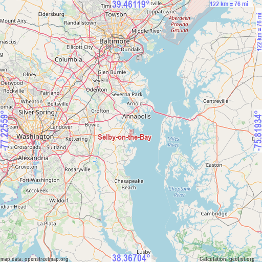
Selby-on-the-Bay GPS coordinates[2]
38° 54' 58.392" North, 76° 31' 20.856" West
| Map corner | latitude | longitude |
|---|---|---|
| Upper-left | 39.46119°, | -77.22559° |
| Center: | 38.91622°, | -76.52246° |
| Lower-right: | 38.36704°, | -75.81934° |
| Map W x H: | 121.7×121.7 km | = 75.6×75.6mi |
| max Lat: | 71.29058° ⇑55.7% North |
| Selby-on-the-Bay: | 38.91622° |
| min Lat: | ⇓44.3% South 19.06759° |
| min Long | Selby-on-the-Ba | max Long |
| -171.73463° | -76.52246° | -66.98998° |
| W 82.5%⇐ | ⇒17.5% E |
Elevation
Elevation of Selby-on-the-Bay is 13 m = 43 ft, and this is 281.8 m = 925 ft below average elevation for this country.
| Max E: |
3189 m = 10463 ft | 91.5% |
| Avg. | 294.8 m = 967 ft | |
| Selby-on-the-Bay | 13 m = 43 ft | |
Min E: |
-60 m = -197 ft | 8.5% |
See also: United States elevation on elevation.city.
Geographical zone
Selby-on-the-Bay is located in North temperate zone (between Tropic of Cancer and the Arctic Circle). Distance of this Northern Tropic circle is 1721.2 km =1069.5 mi to South.| Distance of | km | miles | from Selby-on-the-Bay |
|---|---|---|---|
| North Pole | 5680 | 3529.4 | to North |
| Arctic Circle | 3074.1 | 1910.2 | to North |
| Tropic Cancer | 1721.2 | 1069.5 | to South |
| Equator | 4327.1 | 2688.7 | to South |


Nearby cities:
15 places around Selby-on-the-Bay: (largest is in red/bold)
• Annapolis
7.4 km =4.6 mi,  20°
20°
• Arnold
13 km =8.1 mi,  7°
7°
• Crownsville
14.2 km =8.8 mi,  331°
331°
• Davidsonville
9.2 km =5.7 mi,  274°
274°
• Edgewater
5.1 km =3.2 mi, 332°
• Galesville
8.3 km =5.2 mi,  192°
192°
• Hillsmere Shores
3.6 km =2.2 mi,  41°
41°
• Londontowne
3 km =1.9 mi,  309°
309°
• Mayo
3.3 km =2.1 mi,  163°
163°
• Naval Academy
8.3 km =5.2 mi, 21°
• Parole
7.1 km =4.4 mi,  354°
354°
• Queen Anne
13.6 km =8.5 mi,  261°
261°
• Riva
6.2 km =3.9 mi, 309°
• Robinwood
4.3 km =2.7 mi, 9°
• Shady Side
8.3 km =5.2 mi,  173°
173°
Sources, notices
• [Note1] Compared only with cities in United States existing in our database
• [Src1] Map data: © OpenStreetMap contributors (CC-BY-SA)
• [Src2] Other city data from geonames.org with taken over terms of usage.
• [Src3] Geographical zone / Annual Mean Temperature by Robert A. Rohde @ Wikipedia
