Catonsville geodata
Catonsville (Maryland) is a populated place; located in United States in America/New_York (GMT-4) time zone. With population of 41,567 people, there are 1153 cities with bigger population in this country. Compared to other cities in United States, 52.4% of cities are located further ↑North; 81.7% of cities are located further ←West and 61.7% of cities have higher elevation than Catonsville. Note1


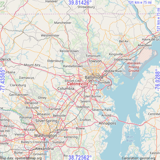
Catonsville GPS coordinates[2]
39° 16' 19.38" North, 76° 43' 54.912" West
| Map corner | latitude | longitude |
|---|---|---|
| Upper-left | 39.81426°, | -77.43505° |
| Center: | 39.27205°, | -76.73192° |
| Lower-right: | 38.72562°, | -76.0288° |
| Map W x H: | 121×121 km | = 75.2×75.2mi |
| max Lat: | 71.29058° ⇑52.4% North |
| Catonsville: | 39.27205° |
| min Lat: | ⇓47.6% South 19.06759° |
| min Long | Catonsville | max Long |
| -171.73463° | -76.73192° | -66.98998° |
| W 81.7%⇐ | ⇒18.3% E |
Elevation
Elevation of Catonsville is 146 m = 479 ft, and this is 148.8 m = 488 ft below average elevation for this country.
| Max E: |
3189 m = 10463 ft | 61.7% |
| Avg. | 294.8 m = 967 ft | |
| Catonsville | 146 m = 479 ft | |
Min E: |
-60 m = -197 ft | 38.3% |
See also: Catonsville elevation on elevation.city.
Geographical zone
Catonsville is located in North temperate zone (between Tropic of Cancer and the Arctic Circle). Distance of this Northern Tropic circle is 1760.7 km =1094 mi to South.| Distance of | km | miles | from Catonsville |
|---|---|---|---|
| North Pole | 5640.4 | 3504.8 | to North |
| Arctic Circle | 3034.5 | 1885.6 | to North |
| Tropic Cancer | 1760.7 | 1094 | to South |
| Equator | 4366.6 | 2713.3 | to South |


Nearby cities:
15 places around Catonsville: (largest is in red/bold)
• Arbutus
3.4 km =2.1 mi,  125°
125°
• Baltimore Highlands
9.3 km =5.8 mi,  117°
117°
• Charlestown
2.3 km =1.4 mi,  100°
100°
• Elkridge
6.8 km =4.2 mi,  166°
166°
• Ellicott City
5.7 km =3.5 mi,  264°
264°
• Hanover
8.8 km =5.5 mi,  175°
175°
• Ilchester
3.7 km =2.3 mi,  230°
230°
• Irvington
4.1 km =2.5 mi,  73°
73°
• Lansdowne
6.8 km =4.2 mi, 115°
• Lochearn
7.7 km =4.8 mi,  6°
6°
• Milford Mill
9 km =5.6 mi,  338°
338°
• Oaklee
4.1 km =2.5 mi, 96°
• Trial
5.7 km =3.5 mi,  198°
198°
• West Elkridge
7.2 km =4.5 mi, 176°
• Woodlawn
5.7 km =3.5 mi,  3°
3°
Sources, notices
• [Note1] Compared only with cities in United States existing in our database
• [Src1] Map data: © OpenStreetMap contributors (CC-BY-SA)
• [Src2] Other city data from geonames.org with taken over terms of usage.
• [Src3] Geographical zone / Annual Mean Temperature by Robert A. Rohde @ Wikipedia
