Ellicott City geodata
Ellicott City (Maryland) is a seat of a second-order administrative division; located in United States in America/New_York (GMT-4) time zone. With population of 65,834 people, there are 651 cities with bigger population in this country. Compared to other cities in United States, 52.5% of cities are located further ↑North; 81.5% of cities are located further ←West and 78.2% of cities have higher elevation than Ellicott City. Note1


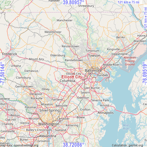
Ellicott City GPS coordinates[2]
39° 16' 2.388" North, 76° 47' 53.916" West
| Map corner | latitude | longitude |
|---|---|---|
| Upper-left | 39.80957°, | -77.50144° |
| Center: | 39.26733°, | -76.79831° |
| Lower-right: | 38.72086°, | -76.09519° |
| Map W x H: | 121.1×121.1 km | = 75.2×75.2mi |
| max Lat: | 71.29058° ⇑52.5% North |
| Ellicott City: | 39.26733° |
| min Lat: | ⇓47.5% South 19.06759° |
| min Long | Ellicott City | max Long |
| -171.73463° | -76.79831° | -66.98998° |
| W 81.5%⇐ | ⇒18.5% E |
Elevation
Elevation of Ellicott City is 55 m = 180 ft, and this is 239.8 m = 787 ft below average elevation for this country.
| Max E: |
3189 m = 10463 ft | 78.2% |
| Avg. | 294.8 m = 967 ft | |
| Ellicott City | 55 m = 180 ft | |
Min E: |
-60 m = -197 ft | 21.8% |
See also: Ellicott City elevation on elevation.city.
Geographical zone
Ellicott City is located in North temperate zone (between Tropic of Cancer and the Arctic Circle). Distance of this Northern Tropic circle is 1760.2 km =1093.7 mi to South.| Distance of | km | miles | from Ellicott City |
|---|---|---|---|
| North Pole | 5640.9 | 3505.1 | to North |
| Arctic Circle | 3035.1 | 1885.9 | to North |
| Tropic Cancer | 1760.2 | 1093.7 | to South |
| Equator | 4366.1 | 2713 | to South |


Nearby cities:
15 places around Ellicott City: (largest is in red/bold)
• Arbutus
8.6 km =5.3 mi,  99°
99°
• Catonsville
5.7 km =3.5 mi,  84°
84°
• Charlestown
8 km =5 mi,  89°
89°
• Columbia
4.6 km =2.9 mi,  229°
229°
• Elkridge
9.5 km =5.9 mi,  129°
129°
• Hanover
10.5 km =6.5 mi,  142°
142°
• Ilchester
3.4 km =2.1 mi,  122°
122°
• Irvington
9.8 km =6.1 mi, 79°
• Lochearn
10.5 km =6.5 mi,  38°
38°
• Milford Mill
9.3 km =5.8 mi,  15°
15°
• Oaklee
9.8 km =6.1 mi, 89°
• Randallstown
11.1 km =6.9 mi,  1°
1°
• Trial
6.3 km =3.9 mi, 141°
• West Elkridge
9.1 km =5.7 mi, 137°
• Woodlawn
8.6 km =5.3 mi, 44°
Sources, notices
• [Note1] Compared only with cities in United States existing in our database
• [Src1] Map data: © OpenStreetMap contributors (CC-BY-SA)
• [Src2] Other city data from geonames.org with taken over terms of usage.
• [Src3] Geographical zone / Annual Mean Temperature by Robert A. Rohde @ Wikipedia
