Milford Mill geodata
Milford Mill (Maryland) is a populated place; located in United States in America/New_York (GMT-4) time zone. With population of 29,042 people, there are 1718 cities with bigger population in this country. Compared to other cities in United States, 51.9% of cities are located further ↑North; 81.6% of cities are located further ←West and 59.9% of cities have higher elevation than Milford Mill. Note1


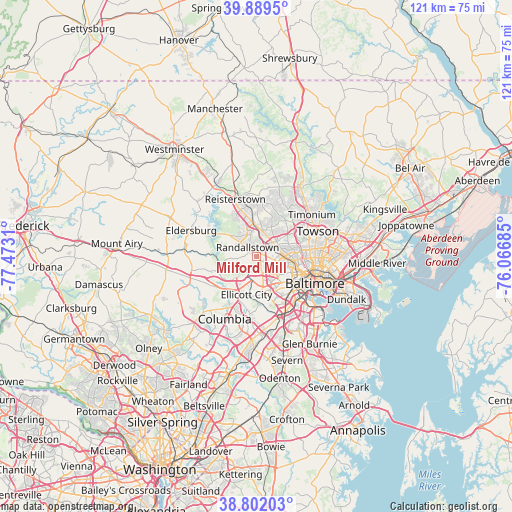
Milford Mill GPS coordinates[2]
39° 20' 52.368" North, 76° 46' 11.892" West
| Map corner | latitude | longitude |
|---|---|---|
| Upper-left | 39.8895°, | -77.4731° |
| Center: | 39.34788°, | -76.76997° |
| Lower-right: | 38.80203°, | -76.06685° |
| Map W x H: | 120.9×120.9 km | = 75.1×75.1mi |
| max Lat: | 71.29058° ⇑51.9% North |
| Milford Mill: | 39.34788° |
| min Lat: | ⇓48.1% South 19.06759° |
| min Long | Milford Mill | max Long |
| -171.73463° | -76.76997° | -66.98998° |
| W 81.6%⇐ | ⇒18.4% E |
Elevation
Elevation of Milford Mill is 155 m = 509 ft, and this is 139.8 m = 459 ft below average elevation for this country.
| Max E: |
3189 m = 10463 ft | 59.9% |
| Avg. | 294.8 m = 967 ft | |
| Milford Mill | 155 m = 509 ft | |
Min E: |
-60 m = -197 ft | 40.1% |
See also: United States elevation on elevation.city.
Geographical zone
Milford Mill is located in North temperate zone (between Tropic of Cancer and the Arctic Circle). Distance of this Northern Tropic circle is 1769.2 km =1099.3 mi to South.| Distance of | km | miles | from Milford Mill |
|---|---|---|---|
| North Pole | 5632 | 3499.6 | to North |
| Arctic Circle | 3026.1 | 1880.3 | to North |
| Tropic Cancer | 1769.2 | 1099.3 | to South |
| Equator | 4375.1 | 2718.6 | to South |


Nearby cities:
15 places around Milford Mill: (largest is in red/bold)
• Arbutus
12 km =7.5 mi,  149°
149°
• Arlington
7.5 km =4.7 mi,  89°
89°
• Catonsville
9 km =5.6 mi,  158°
158°
• Charlestown
10.5 km =6.5 mi, 147°
• Columbia
13.4 km =8.3 mi,  206°
206°
• Ellicott City
9.3 km =5.8 mi,  195°
195°
• Garrison
6.5 km =4 mi,  7°
7°
• Ilchester
10.8 km =6.7 mi,  177°
177°
• Irvington
10.2 km =6.3 mi,  135°
135°
• Lochearn
4.2 km =2.6 mi,  101°
101°
• Oaklee
11.5 km =7.1 mi, 140°
• Owings Mills
8 km =5 mi,  353°
353°
• Pikesville
5 km =3.1 mi,  54°
54°
• Randallstown
3.1 km =1.9 mi,  314°
314°
• Woodlawn
4.6 km =2.9 mi,  127°
127°
Sources, notices
• [Note1] Compared only with cities in United States existing in our database
• [Src1] Map data: © OpenStreetMap contributors (CC-BY-SA)
• [Src2] Other city data from geonames.org with taken over terms of usage.
• [Src3] Geographical zone / Annual Mean Temperature by Robert A. Rohde @ Wikipedia
