Chesapeake City geodata
Chesapeake City (Maryland) is a populated place; located in United States in America/New_York (GMT-4) time zone. With population of 691 people, there are 18770 cities with bigger population in this country. Compared to other cities in United States, 50.6% of cities are located further ↑North; 84.7% of cities are located further ←West and 94.8% of cities have higher elevation than Chesapeake City. Note1


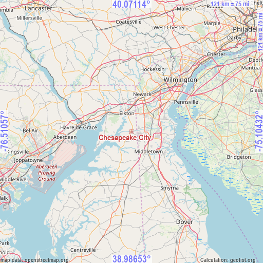
Chesapeake City GPS coordinates[2]
39° 31' 51.42" North, 75° 48' 26.784" West
| Map corner | latitude | longitude |
|---|---|---|
| Upper-left | 40.07114°, | -76.51057° |
| Center: | 39.53095°, | -75.80744° |
| Lower-right: | 38.98653°, | -75.10432° |
| Map W x H: | 120.6×120.6 km | = 74.9×74.9mi |
| max Lat: | 71.29058° ⇑50.6% North |
| Chesapeake City: | 39.53095° |
| min Lat: | ⇓49.4% South 19.06759° |
| min Long | Chesapeake City | max Long |
| -171.73463° | -75.80744° | -66.98998° |
| W 84.7%⇐ | ⇒15.3% E |
Elevation
Elevation of Chesapeake City is 9 m = 30 ft, and this is 285.8 m = 938 ft below average elevation for this country.
| Max E: |
3189 m = 10463 ft | 94.8% |
| Avg. | 294.8 m = 967 ft | |
| Chesapeake City | 9 m = 30 ft | |
Min E: |
-60 m = -197 ft | 5.2% |
See also: United States elevation on elevation.city.
Geographical zone
Chesapeake City is located in North temperate zone (between Tropic of Cancer and the Arctic Circle). Distance of this Northern Tropic circle is 1789.5 km =1111.9 mi to South.| Distance of | km | miles | from Chesapeake City |
|---|---|---|---|
| North Pole | 5611.6 | 3486.9 | to North |
| Arctic Circle | 3005.7 | 1867.7 | to North |
| Tropic Cancer | 1789.5 | 1111.9 | to South |
| Equator | 4395.4 | 2731.2 | to South |


Nearby cities:
15 places around Chesapeake City: (largest is in red/bold)
• Bear
16.8 km =10.4 mi,  49°
49°
• Brookside
16.6 km =10.3 mi,  24°
24°
• Cecilton
15 km =9.3 mi,  200°
200°
• Charlestown
15.1 km =9.4 mi,  288°
288°
• Delaware City
19.5 km =12.1 mi,  74°
74°
• Elkton
8.7 km =5.4 mi,  345°
345°
• Galena
22 km =13.7 mi, 196°
• Glasgow
9.8 km =6.1 mi,  32°
32°
• Havre de Grace
24.5 km =15.2 mi,  274°
274°
• Middletown
12 km =7.5 mi,  139°
139°
• Newark
17.7 km =11 mi, 16°
• North East
13.8 km =8.6 mi,  303°
303°
• Perryville
22.9 km =14.2 mi,  278°
278°
• Pike Creek
23.9 km =14.9 mi, 21°
• Townsend
18.1 km =11.2 mi,  146°
146°
Sources, notices
• [Note1] Compared only with cities in United States existing in our database
• [Src1] Map data: © OpenStreetMap contributors (CC-BY-SA)
• [Src2] Other city data from geonames.org with taken over terms of usage.
• [Src3] Geographical zone / Annual Mean Temperature by Robert A. Rohde @ Wikipedia
