Elkton geodata
Elkton (Maryland) is a seat of a second-order administrative division; located in United States in America/New_York (GMT-4) time zone. With population of 15,782 people, there are 3101 cities with bigger population in this country. Compared to other cities in United States, 50% of cities are located further ↓South; 84.6% of cities are located further ←West and 95.7% of cities have higher elevation than Elkton. Note1


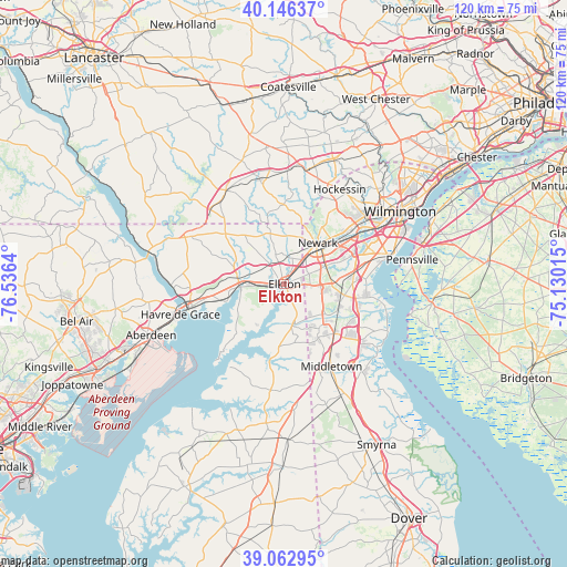
Elkton GPS coordinates[2]
39° 36' 24.408" North, 75° 49' 59.772" West
| Map corner | latitude | longitude |
|---|---|---|
| Upper-left | 40.14637°, | -76.5364° |
| Center: | 39.60678°, | -75.83327° |
| Lower-right: | 39.06295°, | -75.13015° |
| Map W x H: | 120.5×120.5 km | = 74.9×74.9mi |
| max Lat: | 71.29058° ⇑50% North |
| Elkton: | 39.60678° |
| min Lat: | ⇓50% South 19.06759° |
| min Long | Elkton | max Long |
| -171.73463° | -75.83327° | -66.98998° |
| W 84.6%⇐ | ⇒15.4% E |
Elevation
Elevation of Elkton is 8 m = 26 ft, and this is 286.8 m = 941 ft below average elevation for this country.
| Max E: |
3189 m = 10463 ft | 95.7% |
| Avg. | 294.8 m = 967 ft | |
| Elkton | 8 m = 26 ft | |
Min E: |
-60 m = -197 ft | 4.3% |
See also: United States elevation on elevation.city.
Geographical zone
Elkton is located in North temperate zone (between Tropic of Cancer and the Arctic Circle). Distance of this Northern Tropic circle is 1797.9 km =1117.2 mi to South.| Distance of | km | miles | from Elkton |
|---|---|---|---|
| North Pole | 5603.2 | 3481.7 | to North |
| Arctic Circle | 2997.3 | 1862.4 | to North |
| Tropic Cancer | 1797.9 | 1117.2 | to South |
| Equator | 4403.9 | 2736.5 | to South |


Nearby cities:
15 places around Elkton: (largest is in red/bold)
• Bear
15.2 km =9.4 mi,  80°
80°
• Brookside
11.3 km =7 mi,  53°
53°
• Charlestown
12.7 km =7.9 mi,  253°
253°
• Chesapeake City
8.7 km =5.4 mi,  165°
165°
• Delaware City
21.2 km =13.2 mi,  98°
98°
• Glasgow
7.5 km =4.7 mi,  91°
91°
• Middletown
20.2 km =12.6 mi,  150°
150°
• Newark
11.2 km =7 mi,  39°
39°
• Newport
22.6 km =14 mi,  58°
58°
• North East
9.3 km =5.8 mi,  265°
265°
• North Star
19.8 km =12.3 mi,  29°
29°
• Perryville
21.1 km =13.1 mi,  255°
255°
• Pike Creek
17.7 km =11 mi, 38°
• Pike Creek Valley
18.5 km =11.5 mi, 38°
• Rising Sun
22.1 km =13.7 mi,  297°
297°
Sources, notices
• [Note1] Compared only with cities in United States existing in our database
• [Src1] Map data: © OpenStreetMap contributors (CC-BY-SA)
• [Src2] Other city data from geonames.org with taken over terms of usage.
• [Src3] Geographical zone / Annual Mean Temperature by Robert A. Rohde @ Wikipedia
