North East geodata
North East (Maryland) is a populated place; located in United States in America/New_York (GMT-4) time zone. With population of 3,723 people, there are 8558 cities with bigger population in this country. Compared to other cities in United States, 50.1% of cities are located further ↑North; 84.3% of cities are located further ←West and 98.1% of cities have higher elevation than North East. Note1


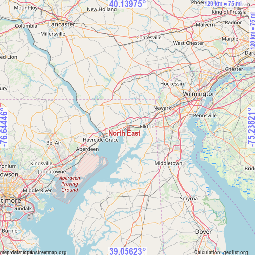
North East GPS coordinates[2]
39° 36' 0.396" North, 75° 56' 28.788" West
| Map corner | latitude | longitude |
|---|---|---|
| Upper-left | 40.13975°, | -76.64446° |
| Center: | 39.60011°, | -75.94133° |
| Lower-right: | 39.05623°, | -75.23821° |
| Map W x H: | 120.5×120.5 km | = 74.9×74.9mi |
| max Lat: | 71.29058° ⇑50.1% North |
| North East: | 39.60011° |
| min Lat: | ⇓49.9% South 19.06759° |
| min Long | North East | max Long |
| -171.73463° | -75.94133° | -66.98998° |
| W 84.3%⇐ | ⇒15.7% E |
Elevation
Elevation of North East is 5 m = 16 ft, and this is 289.8 m = 951 ft below average elevation for this country.
| Max E: |
3189 m = 10463 ft | 98.1% |
| Avg. | 294.8 m = 967 ft | |
| North East | 5 m = 16 ft | |
Min E: |
-60 m = -197 ft | 1.9% |
See also: United States elevation on elevation.city.
Geographical zone
North East is located in North temperate zone (between Tropic of Cancer and the Arctic Circle). Distance of this Northern Tropic circle is 1797.2 km =1116.7 mi to South.| Distance of | km | miles | from North East |
|---|---|---|---|
| North Pole | 5603.9 | 3482.1 | to North |
| Arctic Circle | 2998.1 | 1862.9 | to North |
| Tropic Cancer | 1797.2 | 1116.7 | to South |
| Equator | 4403.1 | 2736 | to South |


Nearby cities:
15 places around North East: (largest is in red/bold)
• Aberdeen
21.6 km =13.4 mi,  242°
242°
• Aberdeen Proving Ground
22 km =13.7 mi,  227°
227°
• Bear
24.5 km =15.2 mi,  82°
82°
• Brookside
19.8 km =12.3 mi,  67°
67°
• Cecilton
22.7 km =14.1 mi,  163°
163°
• Charlestown
4.1 km =2.5 mi,  224°
224°
• Chesapeake City
13.8 km =8.6 mi,  123°
123°
• Elkton
9.3 km =5.8 mi,  85°
85°
• Glasgow
16.8 km =10.4 mi, 88°
• Havre de Grace
14.1 km =8.8 mi,  246°
246°
• Newark
18.9 km =11.7 mi,  60°
60°
• Oxford
20.8 km =12.9 mi,  351°
351°
• Perryville
12 km =7.5 mi, 248°
• Port Deposit
14.9 km =9.3 mi,  272°
272°
• Rising Sun
15 km =9.3 mi,  316°
316°
Sources, notices
• [Note1] Compared only with cities in United States existing in our database
• [Src1] Map data: © OpenStreetMap contributors (CC-BY-SA)
• [Src2] Other city data from geonames.org with taken over terms of usage.
• [Src3] Geographical zone / Annual Mean Temperature by Robert A. Rohde @ Wikipedia
