Chestertown geodata
Chestertown (Maryland) is a seat of a second-order administrative division; located in United States in America/New_York (GMT-4) time zone. With population of 5,093 people, there are 7084 cities with bigger population in this country. Compared to other cities in United States, 53% of cities are located further ↑North; 83.8% of cities are located further ←West and 96.6% of cities have higher elevation than Chestertown. Note1


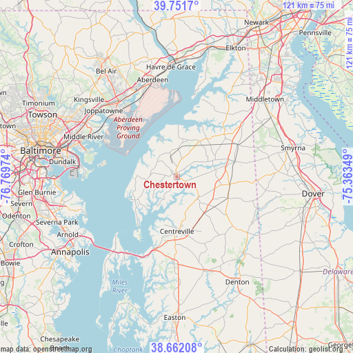
Chestertown GPS coordinates[2]
39° 12' 32.4" North, 76° 3' 59.796" West
| Map corner | latitude | longitude |
|---|---|---|
| Upper-left | 39.7517°, | -76.76974° |
| Center: | 39.209°, | -76.06661° |
| Lower-right: | 38.66208°, | -75.36349° |
| Map W x H: | 121.2×121.2 km | = 75.3×75.3mi |
| max Lat: | 71.29058° ⇑53% North |
| Chestertown: | 39.209° |
| min Lat: | ⇓47% South 19.06759° |
| min Long | Chestertown | max Long |
| -171.73463° | -76.06661° | -66.98998° |
| W 83.8%⇐ | ⇒16.2% E |
Elevation
Elevation of Chestertown is 7 m = 23 ft, and this is 287.8 m = 944 ft below average elevation for this country.
| Max E: |
3189 m = 10463 ft | 96.6% |
| Avg. | 294.8 m = 967 ft | |
| Chestertown | 7 m = 23 ft | |
Min E: |
-60 m = -197 ft | 3.4% |
See also: United States elevation on elevation.city.
Geographical zone
Chestertown is located in North temperate zone (between Tropic of Cancer and the Arctic Circle). Distance of this Northern Tropic circle is 1753.7 km =1089.7 mi to South.| Distance of | km | miles | from Chestertown |
|---|---|---|---|
| North Pole | 5647.4 | 3509.1 | to North |
| Arctic Circle | 3041.5 | 1889.9 | to North |
| Tropic Cancer | 1753.7 | 1089.7 | to South |
| Equator | 4359.6 | 2708.9 | to South |


Nearby cities:
15 places around Chestertown: (largest is in red/bold)
• Aberdeen Proving Ground
29.2 km =18.1 mi,  349°
349°
• Bowleys Quarters
31.2 km =19.4 mi,  296°
296°
• Butlertown
8.8 km =5.5 mi,  338°
338°
• Cecilton
27.6 km =17.1 mi,  38°
38°
• Centreville
18.6 km =11.6 mi,  179°
179°
• Church Hill
10.3 km =6.4 mi,  137°
137°
• Edgewood
30.5 km =19 mi,  319°
319°
• Galena
21.8 km =13.5 mi,  47°
47°
• Grasonville
30.5 km =19 mi,  203°
203°
• Kent Narrows
30.6 km =19 mi,  209°
209°
• Kingstown
1.4 km =0.9 mi,  109°
109°
• Millington
20.5 km =12.7 mi,  74°
74°
• Perryman
31.3 km =19.4 mi, 337°
• Queenstown
25.5 km =15.8 mi, 197°
• Rock Hall
16.5 km =10.3 mi,  241°
241°
Sources, notices
• [Note1] Compared only with cities in United States existing in our database
• [Src1] Map data: © OpenStreetMap contributors (CC-BY-SA)
• [Src2] Other city data from geonames.org with taken over terms of usage.
• [Src3] Geographical zone / Annual Mean Temperature by Robert A. Rohde @ Wikipedia
