Aberdeen Proving Ground geodata
Aberdeen Proving Ground (Maryland) is a populated place; located in United States in America/New_York (GMT-4) time zone. With population of 2,093 people, there are 11646 cities with bigger population in this country. Compared to other cities in United States, 51.1% of cities are located further ↑North; 83.6% of cities are located further ←West and 94.8% of cities have higher elevation than Aberdeen Proving Ground. Note1
Current local time in Aberdeen Proving Ground:
08:53 AM, WednesdayDifference from your time zone: hours


Aberdeen Proving Ground GPS coordinates[2]
39° 28' 0.696" North, 76° 7' 50.376" West
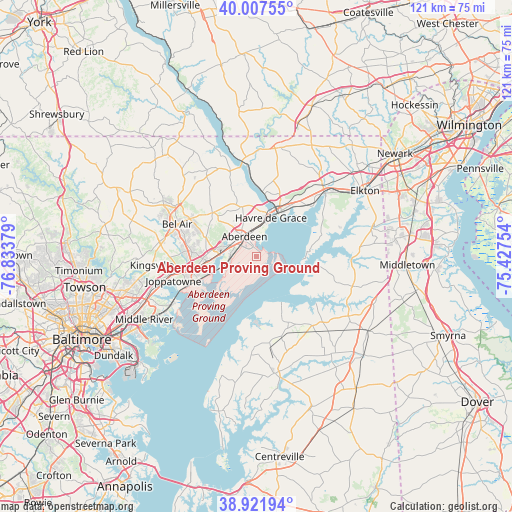
| Map corner | latitude | longitude |
|---|---|---|
| Upper-left | 40.00755°, | -76.83379° |
| Center: | 39.46686°, | -76.13066° |
| Lower-right: | 38.92194°, | -75.42754° |
| Map W x H: | 120.7×120.7 km | = 75×75mi |
| max Lat: | 71.29058° ⇑51.1% North |
| Aberdeen Proving Ground: | 39.46686° |
| min Lat: | ⇓48.9% South 19.06759° |
| min Long | Aberdeen Provin | max Long |
| -171.73463° | -76.13066° | -66.98998° |
| W 83.6%⇐ | ⇒16.4% E |
Elevation
Elevation of Aberdeen Proving Ground is 9 m = 30 ft, and this is 285.8 m = 938 ft below average elevation for this country.
| Max E: |
3189 m = 10463 ft | 94.8% |
| Avg. | 294.8 m = 967 ft | |
| Aberdeen Proving Ground | 9 m = 30 ft | |
Min E: |
-60 m = -197 ft | 5.2% |
See also: United States elevation on elevation.city.
Geographical zone
Aberdeen Proving Ground is located in North temperate zone (between Tropic of Cancer and the Arctic Circle). Distance of this Northern Tropic circle is 1782.4 km =1107.5 mi to South.| Distance of | km | miles | from Aberdeen Proving Ground |
|---|---|---|---|
| North Pole | 5618.8 | 3491.4 | to North |
| Arctic Circle | 3012.9 | 1872.1 | to North |
| Tropic Cancer | 1782.4 | 1107.5 | to South |
| Equator | 4388.3 | 2726.8 | to South |


Nearby cities:
15 places around Aberdeen Proving Ground: (largest is in red/bold)
• Aberdeen
5.5 km =3.4 mi,  328°
328°
• Bel Air
20.2 km =12.6 mi,  292°
292°
• Bel Air South
16.8 km =10.4 mi,  284°
284°
• Butlertown
20.6 km =12.8 mi,  173°
173°
• Charlestown
17.9 km =11.1 mi,  48°
48°
• Edgewood
15 km =9.3 mi,  249°
249°
• Havre de Grace
9.8 km =6.1 mi,  20°
20°
• Joppatowne
19.3 km =12 mi,  267°
267°
• North Bel Air
20.9 km =13 mi, 292°
• North East
22 km =13.7 mi, 47°
• Perryman
6.3 km =3.9 mi, 272°
• Perryville
11.5 km =7.1 mi,  26°
26°
• Port Deposit
15.4 km =9.6 mi,  4°
4°
• Riverside
9.5 km =5.9 mi, 274°
• South Bel Air
19.2 km =11.9 mi, 292°
Sources, notices
• [Note1] Compared only with cities in United States existing in our database
• [Src1] Map data: © OpenStreetMap contributors (CC-BY-SA)
• [Src2] Other city data from geonames.org with taken over terms of usage.
• [Src3] Geographical zone / Annual Mean Temperature by Robert A. Rohde @ Wikipedia
