Columbia geodata
Columbia (Maryland) is a populated place; located in United States in America/New_York (GMT-4) time zone. With population of 99,615 people, there are 352 cities with bigger population in this country. Compared to other cities in United States, 52.7% of cities are located further ↑North; 81.3% of cities are located further ←West and 66.2% of cities have higher elevation than Columbia. Note1


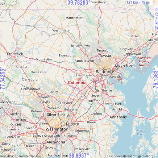
Columbia GPS coordinates[2]
39° 14' 25.368" North, 76° 50' 21.912" West
| Map corner | latitude | longitude |
|---|---|---|
| Upper-left | 39.78283°, | -77.54255° |
| Center: | 39.24038°, | -76.83942° |
| Lower-right: | 38.6937°, | -76.1363° |
| Map W x H: | 121.1×121.1 km | = 75.2×75.2mi |
| max Lat: | 71.29058° ⇑52.7% North |
| Columbia: | 39.24038° |
| min Lat: | ⇓47.3% South 19.06759° |
| min Long | Columbia | max Long |
| -171.73463° | -76.83942° | -66.98998° |
| W 81.3%⇐ | ⇒18.7% E |
Elevation
Elevation of Columbia is 122 m = 400 ft, and this is 172.8 m = 567 ft below average elevation for this country.
| Max E: |
3189 m = 10463 ft | 66.2% |
| Avg. | 294.8 m = 967 ft | |
| Columbia | 122 m = 400 ft | |
Min E: |
-60 m = -197 ft | 33.8% |
See also: Columbia elevation on elevation.city.
Geographical zone
Columbia is located in North temperate zone (between Tropic of Cancer and the Arctic Circle). Distance of this Northern Tropic circle is 1757.2 km =1091.9 mi to South.| Distance of | km | miles | from Columbia |
|---|---|---|---|
| North Pole | 5643.9 | 3507 | to North |
| Arctic Circle | 3038.1 | 1887.8 | to North |
| Tropic Cancer | 1757.2 | 1091.9 | to South |
| Equator | 4363.1 | 2711.1 | to South |


Nearby cities:
15 places around Columbia: (largest is in red/bold)
• Arbutus
12.1 km =7.5 mi,  82°
82°
• Catonsville
9.9 km =6.2 mi,  69°
69°
• Charlestown
12 km =7.5 mi, 75°
• Elkridge
11.3 km =7 mi,  105°
105°
• Ellicott City
4.6 km =2.9 mi,  49°
49°
• Hanover
11.2 km =7 mi,  118°
118°
• Highland
12.2 km =7.6 mi,  236°
236°
• Ilchester
6.5 km =4 mi, 79°
• Jessup
11.5 km =7.1 mi,  151°
151°
• North Laurel
11.6 km =7.2 mi,  193°
193°
• Riverside
8.4 km =5.2 mi,  207°
207°
• Savage
11.5 km =7.1 mi,  173°
173°
• Scaggsville
11.8 km =7.3 mi, 206°
• Trial
7.7 km =4.8 mi,  104°
104°
• West Elkridge
10.4 km =6.5 mi, 110°
Sources, notices
• [Note1] Compared only with cities in United States existing in our database
• [Src1] Map data: © OpenStreetMap contributors (CC-BY-SA)
• [Src2] Other city data from geonames.org with taken over terms of usage.
• [Src3] Geographical zone / Annual Mean Temperature by Robert A. Rohde @ Wikipedia
