Edgemere geodata
Edgemere (Maryland) is a populated place; located in United States in America/New_York (GMT-4) time zone. With population of 8,669 people, there are 4938 cities with bigger population in this country. Compared to other cities in United States, 52.7% of cities are located further ↑North; 82.8% of cities are located further ←West and 94.8% of cities have higher elevation than Edgemere. Note1


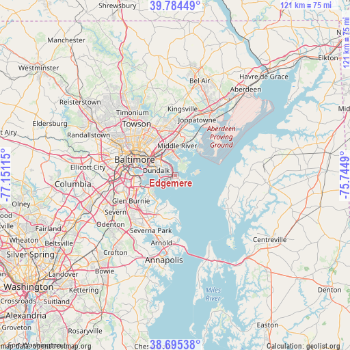
Edgemere GPS coordinates[2]
39° 14' 31.38" North, 76° 26' 52.872" West
| Map corner | latitude | longitude |
|---|---|---|
| Upper-left | 39.78449°, | -77.15115° |
| Center: | 39.24205°, | -76.44802° |
| Lower-right: | 38.69538°, | -75.7449° |
| Map W x H: | 121.1×121.1 km | = 75.2×75.2mi |
| max Lat: | 71.29058° ⇑52.7% North |
| Edgemere: | 39.24205° |
| min Lat: | ⇓47.3% South 19.06759° |
| min Long | Edgemere | max Long |
| -171.73463° | -76.44802° | -66.98998° |
| W 82.8%⇐ | ⇒17.2% E |
Elevation
Elevation of Edgemere is 9 m = 30 ft, and this is 285.8 m = 938 ft below average elevation for this country.
| Max E: |
3189 m = 10463 ft | 94.8% |
| Avg. | 294.8 m = 967 ft | |
| Edgemere | 9 m = 30 ft | |
Min E: |
-60 m = -197 ft | 5.2% |
See also: United States elevation on elevation.city.
Geographical zone
Edgemere is located in North temperate zone (between Tropic of Cancer and the Arctic Circle). Distance of this Northern Tropic circle is 1757.4 km =1092 mi to South.| Distance of | km | miles | from Edgemere |
|---|---|---|---|
| North Pole | 5643.8 | 3506.9 | to North |
| Arctic Circle | 3037.9 | 1887.7 | to North |
| Tropic Cancer | 1757.4 | 1092 | to South |
| Equator | 4363.3 | 2711.2 | to South |


Nearby cities:
15 places around Edgemere: (largest is in red/bold)
• Baltimore
15.1 km =9.4 mi,  290°
290°
• Bowleys Quarters
11.5 km =7.1 mi,  25°
25°
• Brooklyn Park
14.6 km =9.1 mi,  264°
264°
• Butcher's Hill
13.2 km =8.2 mi, 293°
• Dundalk
6.3 km =3.9 mi,  278°
278°
• Essex
7.8 km =4.8 mi,  342°
342°
• Green Haven
14.3 km =8.9 mi,  217°
217°
• Lake Shore
15.3 km =9.5 mi,  191°
191°
• Middle River
10.3 km =6.4 mi,  4°
4°
• Mount Vernon
15.7 km =9.8 mi, 293°
• Overlea
14.9 km =9.3 mi, 335°
• Riviera Beach
9.8 km =6.1 mi,  211°
211°
• Rosedale
10.4 km =6.5 mi,  326°
326°
• Rossville
11.1 km =6.9 mi,  345°
345°
• White Marsh
15.8 km =9.8 mi, 4°
Sources, notices
• [Note1] Compared only with cities in United States existing in our database
• [Src1] Map data: © OpenStreetMap contributors (CC-BY-SA)
• [Src2] Other city data from geonames.org with taken over terms of usage.
• [Src3] Geographical zone / Annual Mean Temperature by Robert A. Rohde @ Wikipedia
