Riviera Beach geodata
Riviera Beach (Maryland) is a populated place; located in United States in America/New_York (GMT-4) time zone. With population of 12,677 people, there are 3735 cities with bigger population in this country. Compared to other cities in United States, 53.3% of cities are located further ↑North; 82.6% of cities are located further ←West and 98.1% of cities have higher elevation than Riviera Beach. Note1


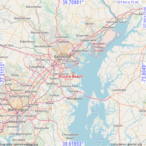
Riviera Beach GPS coordinates[2]
39° 10' 0.408" North, 76° 30' 28.872" West
| Map corner | latitude | longitude |
|---|---|---|
| Upper-left | 39.70981°, | -77.21115° |
| Center: | 39.16678°, | -76.50802° |
| Lower-right: | 38.61953°, | -75.8049° |
| Map W x H: | 121.2×121.2 km | = 75.3×75.3mi |
| max Lat: | 71.29058° ⇑53.3% North |
| Riviera Beach: | 39.16678° |
| min Lat: | ⇓46.7% South 19.06759° |
| min Long | Riviera Beach | max Long |
| -171.73463° | -76.50802° | -66.98998° |
| W 82.6%⇐ | ⇒17.4% E |
Elevation
Elevation of Riviera Beach is 5 m = 16 ft, and this is 289.8 m = 951 ft below average elevation for this country.
| Max E: |
3189 m = 10463 ft | 98.1% |
| Avg. | 294.8 m = 967 ft | |
| Riviera Beach | 5 m = 16 ft | |
Min E: |
-60 m = -197 ft | 1.9% |
See also: United States elevation on elevation.city.
Geographical zone
Riviera Beach is located in North temperate zone (between Tropic of Cancer and the Arctic Circle). Distance of this Northern Tropic circle is 1749 km =1086.8 mi to South.| Distance of | km | miles | from Riviera Beach |
|---|---|---|---|
| North Pole | 5652.1 | 3512.1 | to North |
| Arctic Circle | 3046.2 | 1892.8 | to North |
| Tropic Cancer | 1749 | 1086.8 | to South |
| Equator | 4354.9 | 2706 | to South |


Nearby cities:
15 places around Riviera Beach: (largest is in red/bold)
• Arden on the Severn
12.8 km =8 mi,  208°
208°
• Baltimore Highlands
13.3 km =8.3 mi,  303°
303°
• Brooklyn Park
11.6 km =7.2 mi,  306°
306°
• Dundalk
9.4 km =5.8 mi,  353°
353°
• Edgemere
9.8 km =6.1 mi,  31°
31°
• Ferndale
11.5 km =7.1 mi,  279°
279°
• Glen Burnie
10.1 km =6.3 mi,  267°
267°
• Green Haven
4.6 km =2.9 mi,  228°
228°
• Herald Harbor
13.6 km =8.5 mi,  202°
202°
• Lake Shore
6.9 km =4.3 mi,  163°
163°
• Linthicum
13.2 km =8.2 mi,  288°
288°
• Pasadena
8.6 km =5.3 mi,  219°
219°
• Pumphrey
12.5 km =7.8 mi, 296°
• Severna Park
11.2 km =7 mi, 196°
• South Gate
11 km =6.8 mi,  247°
247°
Sources, notices
• [Note1] Compared only with cities in United States existing in our database
• [Src1] Map data: © OpenStreetMap contributors (CC-BY-SA)
• [Src2] Other city data from geonames.org with taken over terms of usage.
• [Src3] Geographical zone / Annual Mean Temperature by Robert A. Rohde @ Wikipedia
