Fort George G Mead Junction geodata
Fort George G Mead Junction (Maryland) is a populated place; located in United States in America/New_York (GMT-4) time zone. With population of 9,505 people, there are 4621 cities with bigger population in this country. Compared to other cities in United States, 53.7% of cities are located further ↑North; 81.5% of cities are located further ←West and 78.6% of cities have higher elevation than Fort George G Mead Junction. Note1
Current local time in Fort George G Mead Junction:
05:01 AM, FridayDifference from your time zone: hours


Fort George G Mead Junction GPS coordinates[2]
39° 7' 33.384" North, 76° 47' 20.904" West
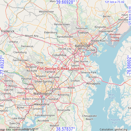
| Map corner | latitude | longitude |
|---|---|---|
| Upper-left | 39.66928°, | -77.49227° |
| Center: | 39.12594°, | -76.78914° |
| Lower-right: | 38.57837°, | -76.08602° |
| Map W x H: | 121.3×121.3 km | = 75.4×75.4mi |
| max Lat: | 71.29058° ⇑53.7% North |
| Fort George G Mead Junction: | 39.12594° |
| min Lat: | ⇓46.3% South 19.06759° |
| min Long | Fort George G M | max Long |
| -171.73463° | -76.78914° | -66.98998° |
| W 81.5%⇐ | ⇒18.5% E |
Elevation
Elevation of Fort George G Mead Junction is 53 m = 174 ft, and this is 241.8 m = 793 ft below average elevation for this country.
| Max E: |
3189 m = 10463 ft | 78.6% |
| Avg. | 294.8 m = 967 ft | |
| Fort George G Mead Junction | 53 m = 174 ft | |
Min E: |
-60 m = -197 ft | 21.4% |
See also: United States elevation on elevation.city.
Geographical zone
Fort George G Mead Junction is located in North temperate zone (between Tropic of Cancer and the Arctic Circle). Distance of this Northern Tropic circle is 1744.5 km =1084 mi to South.| Distance of | km | miles | from Fort George G Mead Junction |
|---|---|---|---|
| North Pole | 5656.7 | 3514.9 | to North |
| Arctic Circle | 3050.8 | 1895.7 | to North |
| Tropic Cancer | 1744.5 | 1084 | to South |
| Equator | 4350.4 | 2703.2 | to South |


Nearby cities:
15 places around Fort George G Mead Junction: (largest is in red/bold)
• Fort Meade
4.4 km =2.7 mi,  116°
116°
• Hanover
9.3 km =5.8 mi,  36°
36°
• Jessup
2.9 km =1.8 mi,  24°
24°
• Laurel
5.9 km =3.7 mi,  239°
239°
• Maryland City
4.5 km =2.8 mi,  213°
213°
• North Laurel
7.2 km =4.5 mi,  281°
281°
• Odenton
9 km =5.6 mi, 121°
• Riverside
9.8 km =6.1 mi,  302°
302°
• Savage
3.3 km =2.1 mi,  293°
293°
• Scaggsville
9.8 km =6.1 mi, 282°
• Severn
7.9 km =4.9 mi,  81°
81°
• South Laurel
8.2 km =5.1 mi,  220°
220°
• Trial
11.3 km =7 mi, 16°
• West Elkridge
10.5 km =6.5 mi,  30°
30°
• West Laurel
9.9 km =6.2 mi,  253°
253°
Sources, notices
• [Note1] Compared only with cities in United States existing in our database
• [Src1] Map data: © OpenStreetMap contributors (CC-BY-SA)
• [Src2] Other city data from geonames.org with taken over terms of usage.
• [Src3] Geographical zone / Annual Mean Temperature by Robert A. Rohde @ Wikipedia
