Severn geodata
Severn (Maryland) is a populated place; located in United States in America/New_York (GMT-4) time zone. With population of 44,231 people, there are 1076 cities with bigger population in this country. Compared to other cities in United States, 53.6% of cities are located further ↑North; 81.9% of cities are located further ←West and 79.5% of cities have higher elevation than Severn. Note1


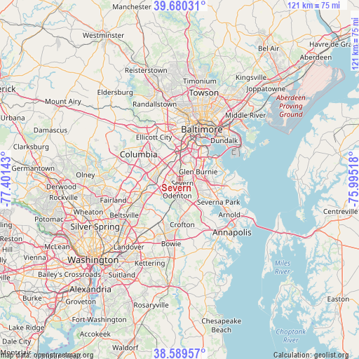
Severn GPS coordinates[2]
39° 8' 13.38" North, 76° 41' 53.88" West
| Map corner | latitude | longitude |
|---|---|---|
| Upper-left | 39.68031°, | -77.40143° |
| Center: | 39.13705°, | -76.6983° |
| Lower-right: | 38.58957°, | -75.99518° |
| Map W x H: | 121.3×121.3 km | = 75.4×75.4mi |
| max Lat: | 71.29058° ⇑53.6% North |
| Severn: | 39.13705° |
| min Lat: | ⇓46.4% South 19.06759° |
| min Long | Severn | max Long |
| -171.73463° | -76.6983° | -66.98998° |
| W 81.9%⇐ | ⇒18.1% E |
Elevation
Elevation of Severn is 49 m = 161 ft, and this is 245.8 m = 806 ft below average elevation for this country.
| Max E: |
3189 m = 10463 ft | 79.5% |
| Avg. | 294.8 m = 967 ft | |
| Severn | 49 m = 161 ft | |
Min E: |
-60 m = -197 ft | 20.5% |
See also: Severn elevation on elevation.city.
Geographical zone
Severn is located in North temperate zone (between Tropic of Cancer and the Arctic Circle). Distance of this Northern Tropic circle is 1745.7 km =1084.7 mi to South.| Distance of | km | miles | from Severn |
|---|---|---|---|
| North Pole | 5655.4 | 3514.1 | to North |
| Arctic Circle | 3049.5 | 1894.9 | to North |
| Tropic Cancer | 1745.7 | 1084.7 | to South |
| Equator | 4351.6 | 2704 | to South |


Nearby cities:
15 places around Severn: (largest is in red/bold)
• Elkridge
8.5 km =5.3 mi,  351°
351°
• Ferndale
7.2 km =4.5 mi,  44°
44°
• Fort George G Mead Junction
7.9 km =4.9 mi,  261°
261°
• Fort Meade
5 km =3.1 mi,  230°
230°
• Gambrills
8.3 km =5.2 mi,  159°
159°
• Glen Burnie
7 km =4.3 mi,  65°
65°
• Hanover
6.6 km =4.1 mi,  340°
340°
• Jessup
6.8 km =4.2 mi,  281°
281°
• Linthicum
8.5 km =5.3 mi,  27°
27°
• Odenton
5.9 km =3.7 mi,  181°
181°
• Pumphrey
10.4 km =6.5 mi, 30°
• Savage
10.8 km =6.7 mi,  270°
270°
• South Gate
6.3 km =3.9 mi,  98°
98°
• Trial
10.7 km =6.6 mi,  334°
334°
• West Elkridge
8.2 km =5.1 mi, 342°
Sources, notices
• [Note1] Compared only with cities in United States existing in our database
• [Src1] Map data: © OpenStreetMap contributors (CC-BY-SA)
• [Src2] Other city data from geonames.org with taken over terms of usage.
• [Src3] Geographical zone / Annual Mean Temperature by Robert A. Rohde @ Wikipedia
