Bowie geodata
Bowie (Maryland) is a populated place; located in United States in America/New_York (GMT-4) time zone. With population of 58,025 people, there are 785 cities with bigger population in this country. Compared to other cities in United States, 55.5% of cities are located further ↑North; 81.7% of cities are located further ←West and 80.9% of cities have higher elevation than Bowie. Note1


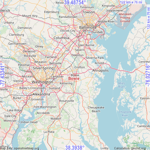
Bowie GPS coordinates[2]
38° 56' 34.008" North, 76° 43' 49.008" West
| Map corner | latitude | longitude |
|---|---|---|
| Upper-left | 39.48754°, | -77.43341° |
| Center: | 38.94278°, | -76.73028° |
| Lower-right: | 38.3938°, | -76.02716° |
| Map W x H: | 121.6×121.6 km | = 75.6×75.6mi |
| max Lat: | 71.29058° ⇑55.5% North |
| Bowie: | 38.94278° |
| min Lat: | ⇓44.5% South 19.06759° |
| min Long | Bowie | max Long |
| -171.73463° | -76.73028° | -66.98998° |
| W 81.7%⇐ | ⇒18.3% E |
Elevation
Elevation of Bowie is 43 m = 141 ft, and this is 251.8 m = 826 ft below average elevation for this country.
| Max E: |
3189 m = 10463 ft | 80.9% |
| Avg. | 294.8 m = 967 ft | |
| Bowie | 43 m = 141 ft | |
Min E: |
-60 m = -197 ft | 19.1% |
See also: Bowie elevation on elevation.city.
Geographical zone
Bowie is located in North temperate zone (between Tropic of Cancer and the Arctic Circle). Distance of this Northern Tropic circle is 1724.1 km =1071.3 mi to South.| Distance of | km | miles | from Bowie |
|---|---|---|---|
| North Pole | 5677 | 3527.5 | to North |
| Arctic Circle | 3071.1 | 1908.3 | to North |
| Tropic Cancer | 1724.1 | 1071.3 | to South |
| Equator | 4330 | 2690.5 | to South |


Nearby cities:
15 places around Bowie: (largest is in red/bold)
• Brock Hall
10.6 km =6.6 mi,  194°
194°
• Crofton
7.5 km =4.7 mi,  29°
29°
• Davidsonville
9.1 km =5.7 mi,  104°
104°
• Fairwood
4.4 km =2.7 mi,  290°
290°
• Glenarden
11.5 km =7.1 mi,  262°
262°
• Glenn Dale
9.3 km =5.8 mi,  302°
302°
• Kettering
9.8 km =6.1 mi,  228°
228°
• Lake Arbor
9.4 km =5.8 mi,  245°
245°
• Lanham-Seabrook
10.8 km =6.7 mi, 285°
• Largo
10 km =6.2 mi,  239°
239°
• Mitchellville
2.2 km =1.4 mi,  208°
208°
• Queen Anne
6.6 km =4.1 mi,  137°
137°
• Seabrook
10.4 km =6.5 mi, 285°
• Springdale
9.4 km =5.8 mi,  266°
266°
• Woodmore
6.7 km =4.2 mi, 249°
Sources, notices
• [Note1] Compared only with cities in United States existing in our database
• [Src1] Map data: © OpenStreetMap contributors (CC-BY-SA)
• [Src2] Other city data from geonames.org with taken over terms of usage.
• [Src3] Geographical zone / Annual Mean Temperature by Robert A. Rohde @ Wikipedia
