Accokeek geodata
Accokeek (Maryland) is a populated place; located in United States in America/New_York (GMT-4) time zone. With population of 10,573 people, there are 4303 cities with bigger population in this country. Compared to other cities in United States, 57.7% of cities are located further ↑North; 80.5% of cities are located further ←West and 75.8% of cities have higher elevation than Accokeek. Note1


Accokeek GPS coordinates[2]
38° 40' 3.432" North, 77° 1' 41.916" West
| Map corner | latitude | longitude |
|---|---|---|
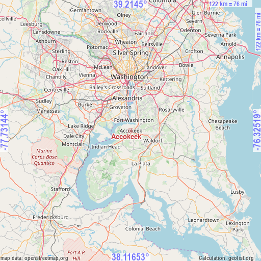
| Upper-left | 39.2145°, | -77.73144° |
| Center: | 38.66762°, | -77.02831° |
| Lower-right: | 38.11653°, | -76.32519° |
| Map W x H: | 122.1×122.1 km | = 75.9×75.9mi |
| max Lat: | 71.29058° ⇑57.7% North |
| Accokeek: | 38.66762° |
| min Lat: | ⇓42.3% South 19.06759° |
| min Long | Accokeek | max Long |
| -171.73463° | -77.02831° | -66.98998° |
| W 80.5%⇐ | ⇒19.5% E |
Elevation
Elevation of Accokeek is 67 m = 220 ft, and this is 227.8 m = 747 ft below average elevation for this country.
| Max E: |
3189 m = 10463 ft | 75.8% |
| Avg. | 294.8 m = 967 ft | |
| Accokeek | 67 m = 220 ft | |
Min E: |
-60 m = -197 ft | 24.2% |
See also: United States elevation on elevation.city.
Geographical zone
Accokeek is located in North temperate zone (between Tropic of Cancer and the Arctic Circle). Distance of this Northern Tropic circle is 1693.5 km =1052.3 mi to South.| Distance of | km | miles | from Accokeek |
|---|---|---|---|
| North Pole | 5707.6 | 3546.5 | to North |
| Arctic Circle | 3101.7 | 1927.3 | to North |
| Tropic Cancer | 1693.5 | 1052.3 | to South |
| Equator | 4299.4 | 2671.5 | to South |


Nearby cities:
15 places around Accokeek: (largest is in red/bold)
• Bennsville
6.6 km =4.1 mi,  167°
167°
• Bryans Road
6 km =3.7 mi,  220°
220°
• Fort Belvoir
11.3 km =7 mi,  295°
295°
• Fort Hunt
7.7 km =4.8 mi,  340°
340°
• Fort Washington
4.4 km =2.7 mi,  5°
5°
• Friendly
10.3 km =6.4 mi,  24°
24°
• Groveton
12.1 km =7.5 mi, 336°
• Hybla Valley
10.1 km =6.3 mi,  331°
331°
• Mount Vernon
8.9 km =5.5 mi,  309°
309°
• Pomfret
10 km =6.2 mi,  181°
181°
• Potomac Heights
11.7 km =7.3 mi,  236°
236°
• Saint Charles
10.6 km =6.6 mi,  132°
132°
• St. Charles
11.2 km =7 mi, 126°
• Waldorf
9.1 km =5.7 mi,  121°
121°
• Woodlawn
10.6 km =6.6 mi, 301°
Sources, notices
• [Note1] Compared only with cities in United States existing in our database
• [Src1] Map data: © OpenStreetMap contributors (CC-BY-SA)
• [Src2] Other city data from geonames.org with taken over terms of usage.
• [Src3] Geographical zone / Annual Mean Temperature by Robert A. Rohde @ Wikipedia
