Bryans Road geodata
Bryans Road (Maryland) is a populated place; located in United States in America/New_York (GMT-4) time zone. With population of 7,244 people, there are 5682 cities with bigger population in this country. Compared to other cities in United States, 57.9% of cities are located further ↑North; 80.2% of cities are located further ←West and 79.3% of cities have higher elevation than Bryans Road. Note1


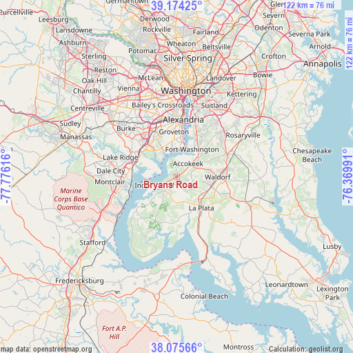
Bryans Road GPS coordinates[2]
38° 37' 37.416" North, 77° 4' 22.908" West
| Map corner | latitude | longitude |
|---|---|---|
| Upper-left | 39.17425°, | -77.77616° |
| Center: | 38.62706°, | -77.07303° |
| Lower-right: | 38.07566°, | -76.36991° |
| Map W x H: | 122.2×122.2 km | = 75.9×75.9mi |
| max Lat: | 71.29058° ⇑57.9% North |
| Bryans Road: | 38.62706° |
| min Lat: | ⇓42.1% South 19.06759° |
| min Long | Bryans Road | max Long |
| -171.73463° | -77.07303° | -66.98998° |
| W 80.2%⇐ | ⇒19.8% E |
Elevation
Elevation of Bryans Road is 50 m = 164 ft, and this is 244.8 m = 803 ft below average elevation for this country.
| Max E: |
3189 m = 10463 ft | 79.3% |
| Avg. | 294.8 m = 967 ft | |
| Bryans Road | 50 m = 164 ft | |
Min E: |
-60 m = -197 ft | 20.7% |
See also: United States elevation on elevation.city.
Geographical zone
Bryans Road is located in North temperate zone (between Tropic of Cancer and the Arctic Circle). Distance of this Northern Tropic circle is 1689 km =1049.5 mi to South.| Distance of | km | miles | from Bryans Road |
|---|---|---|---|
| North Pole | 5712.1 | 3549.3 | to North |
| Arctic Circle | 3106.2 | 1930.1 | to North |
| Tropic Cancer | 1689 | 1049.5 | to South |
| Equator | 4294.9 | 2668.7 | to South |


Nearby cities:
15 places around Bryans Road: (largest is in red/bold)
• Accokeek
6 km =3.7 mi,  40°
40°
• Bennsville
5.6 km =3.5 mi,  110°
110°
• Fort Belvoir
11.4 km =7.1 mi,  326°
326°
• Fort Hunt
11.8 km =7.3 mi,  6°
6°
• Fort Washington
9.9 km =6.2 mi,  25°
25°
• Hybla Valley
13.4 km =8.3 mi,  356°
356°
• Indian Head
8.3 km =5.2 mi,  248°
248°
• La Plata
13.8 km =8.6 mi,  141°
141°
• Mount Vernon
10.7 km =6.6 mi,  343°
343°
• Pomfret
6.6 km =4.1 mi,  146°
146°
• Potomac Heights
6.2 km =3.9 mi, 250°
• Saint Charles
12 km =7.5 mi,  102°
102°
• St. Charles
13.1 km =8.1 mi, 99°
• Waldorf
11.6 km =7.2 mi,  91°
91°
• Woodlawn
11.2 km =7 mi, 332°
Sources, notices
• [Note1] Compared only with cities in United States existing in our database
• [Src1] Map data: © OpenStreetMap contributors (CC-BY-SA)
• [Src2] Other city data from geonames.org with taken over terms of usage.
• [Src3] Geographical zone / Annual Mean Temperature by Robert A. Rohde @ Wikipedia
