Rockville geodata
Rockville (Maryland) is a seat of a second-order administrative division; located in United States in America/New_York (GMT-4) time zone. With population of 66,980 people, there are 629 cities with bigger population in this country. Compared to other cities in United States, 54.1% of cities are located further ↑North; 80% of cities are located further ←West and 62.7% of cities have higher elevation than Rockville. Note1


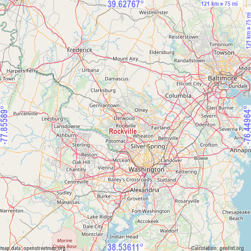
Rockville GPS coordinates[2]
39° 5' 2.4" North, 77° 9' 9.936" West
| Map corner | latitude | longitude |
|---|---|---|
| Upper-left | 39.62767°, | -77.85589° |
| Center: | 39.084°, | -77.15276° |
| Lower-right: | 38.53611°, | -76.44964° |
| Map W x H: | 121.4×121.4 km | = 75.4×75.4mi |
| max Lat: | 71.29058° ⇑54.1% North |
| Rockville: | 39.084° |
| min Lat: | ⇓45.9% South 19.06759° |
| min Long | Rockville | max Long |
| -171.73463° | -77.15276° | -66.98998° |
| W 80%⇐ | ⇒20% E |
Elevation
Elevation of Rockville is 140 m = 459 ft, and this is 154.8 m = 508 ft below average elevation for this country.
| Max E: |
3189 m = 10463 ft | 62.7% |
| Avg. | 294.8 m = 967 ft | |
| Rockville | 140 m = 459 ft | |
Min E: |
-60 m = -197 ft | 37.3% |
See also: Rockville elevation on elevation.city.
Geographical zone
Rockville is located in North temperate zone (between Tropic of Cancer and the Arctic Circle). Distance of this Northern Tropic circle is 1739.8 km =1081.1 mi to South.| Distance of | km | miles | from Rockville |
|---|---|---|---|
| North Pole | 5661.3 | 3517.8 | to North |
| Arctic Circle | 3055.4 | 1898.5 | to North |
| Tropic Cancer | 1739.8 | 1081.1 | to South |
| Equator | 4345.7 | 2700.3 | to South |


Nearby cities:
15 places around Rockville: (largest is in red/bold)
• Aspen Hill
6.9 km =4.3 mi,  94°
94°
• Chevy Chase View
9.4 km =5.8 mi,  139°
139°
• Derwood
3.8 km =2.4 mi,  349°
349°
• Gaithersburg
7.8 km =4.8 mi,  327°
327°
• Garrett Park
7.3 km =4.5 mi,  134°
134°
• Glenmont
9.4 km =5.8 mi,  108°
108°
• Kensington
9.3 km =5.8 mi, 134°
• Layhill
9.4 km =5.8 mi,  84°
84°
• Leisure World
7.5 km =4.7 mi,  74°
74°
• North Bethesda
5.3 km =3.3 mi,  146°
146°
• North Kensington
9.1 km =5.7 mi, 130°
• Potomac
8.8 km =5.5 mi,  213°
213°
• Redland
6.9 km =4.3 mi,  6°
6°
• Rossmoor
7.4 km =4.6 mi, 72°
• Washington Grove
6.5 km =4 mi,  342°
342°
Sources, notices
• [Note1] Compared only with cities in United States existing in our database
• [Src1] Map data: © OpenStreetMap contributors (CC-BY-SA)
• [Src2] Other city data from geonames.org with taken over terms of usage.
• [Src3] Geographical zone / Annual Mean Temperature by Robert A. Rohde @ Wikipedia
