Taneytown geodata
Taneytown (Maryland) is a populated place; located in United States in America/New_York (GMT-4) time zone. With population of 6,746 people, there are 5957 cities with bigger population in this country. Compared to other cities in United States, 50.4% of cities are located further ↓South; 79.9% of cities are located further ←West and 59.9% of cities have higher elevation than Taneytown. Note1


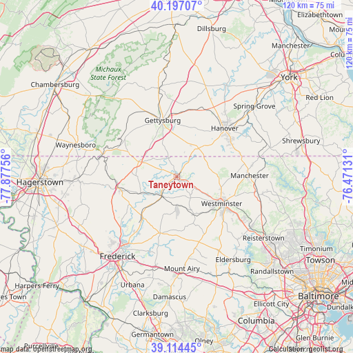
Taneytown GPS coordinates[2]
39° 39' 28.368" North, 77° 10' 27.948" West
| Map corner | latitude | longitude |
|---|---|---|
| Upper-left | 40.19707°, | -77.87756° |
| Center: | 39.65788°, | -77.17443° |
| Lower-right: | 39.11445°, | -76.47131° |
| Map W x H: | 120.4×120.4 km | = 74.8×74.8mi |
| max Lat: | 71.29058° ⇑49.6% North |
| Taneytown: | 39.65788° |
| min Lat: | ⇓50.4% South 19.06759° |
| min Long | Taneytown | max Long |
| -171.73463° | -77.17443° | -66.98998° |
| W 79.9%⇐ | ⇒20.1% E |
Elevation
Elevation of Taneytown is 155 m = 509 ft, and this is 139.8 m = 459 ft below average elevation for this country.
| Max E: |
3189 m = 10463 ft | 59.9% |
| Avg. | 294.8 m = 967 ft | |
| Taneytown | 155 m = 509 ft | |
Min E: |
-60 m = -197 ft | 40.1% |
See also: United States elevation on elevation.city.
Geographical zone
Taneytown is located in North temperate zone (between Tropic of Cancer and the Arctic Circle). Distance of this Northern Tropic circle is 1803.6 km =1120.7 mi to South.| Distance of | km | miles | from Taneytown |
|---|---|---|---|
| North Pole | 5597.5 | 3478.1 | to North |
| Arctic Circle | 2991.6 | 1858.9 | to North |
| Tropic Cancer | 1803.6 | 1120.7 | to South |
| Equator | 4409.5 | 2739.9 | to South |


Nearby cities:
15 places around Taneytown: (largest is in red/bold)
• Bonneauville
17.4 km =10.8 mi,  10°
10°
• Carroll Valley
20.5 km =12.7 mi,  299°
299°
• Emmitsburg
14 km =8.7 mi,  291°
291°
• Gettysburg
19.8 km =12.3 mi,  345°
345°
• Lake Heritage
16.9 km =10.5 mi,  357°
357°
• Libertytown
20 km =12.4 mi,  196°
196°
• Littlestown
12.1 km =7.5 mi,  37°
37°
• McSherrystown
21.7 km =13.5 mi, 40°
• Mount Pleasant
11.9 km =7.4 mi,  45°
45°
• New Windsor
14.1 km =8.8 mi,  156°
156°
• Pennville
21 km =13 mi, 45°
• Thurmont
20.6 km =12.8 mi,  259°
259°
• Union Bridge
9.9 km =6.2 mi,  181°
181°
• Westminster
17.8 km =11.1 mi,  120°
120°
• Woodsboro
18.4 km =11.4 mi,  220°
220°
Sources, notices
• [Note1] Compared only with cities in United States existing in our database
• [Src1] Map data: © OpenStreetMap contributors (CC-BY-SA)
• [Src2] Other city data from geonames.org with taken over terms of usage.
• [Src3] Geographical zone / Annual Mean Temperature by Robert A. Rohde @ Wikipedia
