Littlestown geodata
Littlestown (Pennsylvania) is a populated place; located in United States in America/New_York (GMT-4) time zone. With population of 4,478 people, there are 7667 cities with bigger population in this country. Compared to other cities in United States, 51.1% of cities are located further ↓South; 80.2% of cities are located further ←West and 51.1% of cities have higher elevation than Littlestown. Note1
Administrative division(s):
- Level 1: Pennsylvania
- Level 2: Adams County
- Level 3: Borough of Littlestown


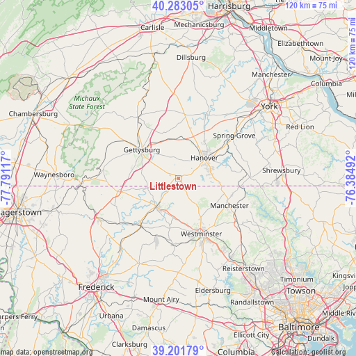
Littlestown GPS coordinates[2]
39° 44' 40.344" North, 77° 5' 16.944" West
| Map corner | latitude | longitude |
|---|---|---|
| Upper-left | 40.28305°, | -77.79117° |
| Center: | 39.74454°, | -77.08804° |
| Lower-right: | 39.20179°, | -76.38492° |
| Map W x H: | 120.2×120.2 km | = 74.7×74.7mi |
| max Lat: | 71.29058° ⇑48.9% North |
| Littlestown: | 39.74454° |
| min Lat: | ⇓51.1% South 19.06759° |
| min Long | Littlestown | max Long |
| -171.73463° | -77.08804° | -66.98998° |
| W 80.2%⇐ | ⇒19.8% E |
Elevation
Elevation of Littlestown is 194 m = 636 ft, and this is 100.8 m = 331 ft below average elevation for this country.
| Max E: |
3189 m = 10463 ft | 51.1% |
| Avg. | 294.8 m = 967 ft | |
| Littlestown | 194 m = 636 ft | |
Min E: |
-60 m = -197 ft | 48.9% |
See also: United States elevation on elevation.city.
Geographical zone
Littlestown is located in North temperate zone (between Tropic of Cancer and the Arctic Circle). Distance of this Northern Tropic circle is 1813.3 km =1126.7 mi to South.| Distance of | km | miles | from Littlestown |
|---|---|---|---|
| North Pole | 5587.9 | 3472.2 | to North |
| Arctic Circle | 2982 | 1852.9 | to North |
| Tropic Cancer | 1813.3 | 1126.7 | to South |
| Equator | 4419.2 | 2746 | to South |


Nearby cities:
15 places around Littlestown: (largest is in red/bold)
• Abbottstown
18.1 km =11.2 mi,  29°
29°
• Bonneauville
8.6 km =5.3 mi,  330°
330°
• Gettysburg
15.5 km =9.6 mi,  308°
308°
• Hanover
10.9 km =6.8 mi,  55°
55°
• Hunterstown
16.5 km =10.3 mi,  338°
338°
• Lake Heritage
10.9 km =6.8 mi, 311°
• Manchester
19.7 km =12.2 mi,  118°
118°
• McSherrystown
9.6 km =6 mi,  43°
43°
• Midway
10.2 km =6.3 mi,  45°
45°
• Mount Pleasant
1.6 km =1 mi,  138°
138°
• New Oxford
13.5 km =8.4 mi,  11°
11°
• Parkville
11.4 km =7.1 mi,  69°
69°
• Pennville
9.2 km =5.7 mi, 56°
• Taneytown
12.1 km =7.5 mi,  217°
217°
• Westminster
20.4 km =12.7 mi,  157°
157°
Sources, notices
• [Note1] Compared only with cities in United States existing in our database
• [Src1] Map data: © OpenStreetMap contributors (CC-BY-SA)
• [Src2] Other city data from geonames.org with taken over terms of usage.
• [Src3] Geographical zone / Annual Mean Temperature by Robert A. Rohde @ Wikipedia
