Westminster geodata
Westminster (Maryland) is a seat of a second-order administrative division; located in United States in America/New_York (GMT-4) time zone. With population of 18,670 people, there are 2699 cities with bigger population in this country. Compared to other cities in United States, 50.3% of cities are located further ↑North; 80.6% of cities are located further ←West and 56.1% of cities have lower elevation than Westminster. Note1


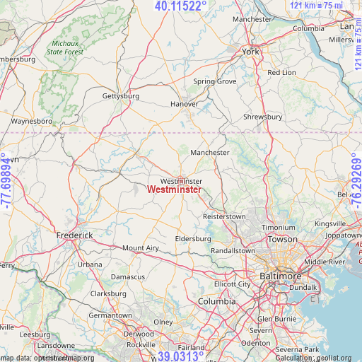
Westminster GPS coordinates[2]
39° 34' 31.368" North, 76° 59' 44.916" West
| Map corner | latitude | longitude |
|---|---|---|
| Upper-left | 40.11522°, | -77.69894° |
| Center: | 39.57538°, | -76.99581° |
| Lower-right: | 39.0313°, | -76.29269° |
| Map W x H: | 120.5×120.5 km | = 74.9×74.9mi |
| max Lat: | 71.29058° ⇑50.3% North |
| Westminster: | 39.57538° |
| min Lat: | ⇓49.7% South 19.06759° |
| min Long | Westminster | max Long |
| -171.73463° | -76.99581° | -66.98998° |
| W 80.6%⇐ | ⇒19.4% E |
Elevation
Elevation of Westminster is 223 m = 732 ft, and this is 71.8 m = 236 ft below average elevation for this country.
| Max E: |
3189 m = 10463 ft | 43.9% |
| Avg. | 294.8 m = 967 ft | |
| Westminster | 223 m = 732 ft | |
Min E: |
-60 m = -197 ft | 56.1% |
See also: United States elevation on elevation.city.
Geographical zone
Westminster is located in North temperate zone (between Tropic of Cancer and the Arctic Circle). Distance of this Northern Tropic circle is 1794.5 km =1115.1 mi to South.| Distance of | km | miles | from Westminster |
|---|---|---|---|
| North Pole | 5606.7 | 3483.8 | to North |
| Arctic Circle | 3000.8 | 1864.6 | to North |
| Tropic Cancer | 1794.5 | 1115.1 | to South |
| Equator | 4400.4 | 2734.3 | to South |


Nearby cities:
15 places around Westminster: (largest is in red/bold)
• Eldersburg
19.5 km =12.1 mi,  168°
168°
• Hampstead
12.9 km =8 mi,  75°
75°
• Hanover
25.1 km =15.6 mi,  2°
2°
• Libertytown
23.2 km =14.4 mi,  244°
244°
• Linganore
23.6 km =14.7 mi,  230°
230°
• Littlestown
20.4 km =12.7 mi,  337°
337°
• Manchester
13.5 km =8.4 mi,  44°
44°
• Mount Pleasant
18.9 km =11.7 mi, 338°
• New Windsor
10.3 km =6.4 mi,  248°
248°
• Parkville
23.1 km =14.4 mi,  6°
6°
• Pennville
23.8 km =14.8 mi,  359°
359°
• Reisterstown
18.3 km =11.4 mi,  129°
129°
• Sykesville
22.6 km =14 mi, 173°
• Taneytown
17.8 km =11.1 mi,  300°
300°
• Union Bridge
15.5 km =9.6 mi,  267°
267°
Sources, notices
• [Note1] Compared only with cities in United States existing in our database
• [Src1] Map data: © OpenStreetMap contributors (CC-BY-SA)
• [Src2] Other city data from geonames.org with taken over terms of usage.
• [Src3] Geographical zone / Annual Mean Temperature by Robert A. Rohde @ Wikipedia
