Wheaton geodata
Wheaton (Maryland) is a populated place; located in United States in America/New_York (GMT-4) time zone. With population of 48,284 people, there are 995 cities with bigger population in this country. Compared to other cities in United States, 54.4% of cities are located further ↑North; 80.4% of cities are located further ←West and 61.7% of cities have higher elevation than Wheaton. Note1


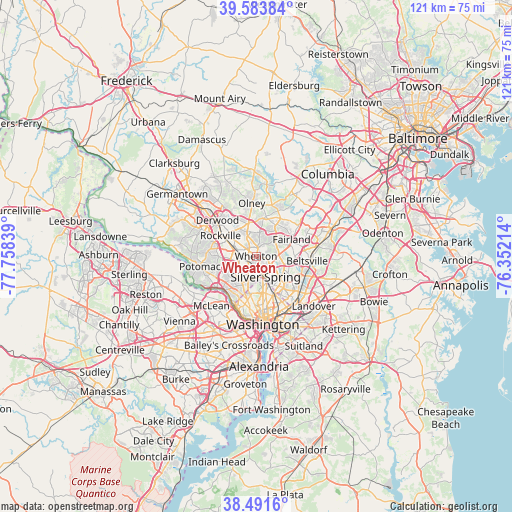
Wheaton GPS coordinates[2]
39° 2' 23.388" North, 77° 3' 18.936" West
| Map corner | latitude | longitude |
|---|---|---|
| Upper-left | 39.58384°, | -77.75839° |
| Center: | 39.03983°, | -77.05526° |
| Lower-right: | 38.4916°, | -76.35214° |
| Map W x H: | 121.4×121.4 km | = 75.4×75.4mi |
| max Lat: | 71.29058° ⇑54.4% North |
| Wheaton: | 39.03983° |
| min Lat: | ⇓45.6% South 19.06759° |
| min Long | Wheaton | max Long |
| -171.73463° | -77.05526° | -66.98998° |
| W 80.4%⇐ | ⇒19.6% E |
Elevation
Elevation of Wheaton is 146 m = 479 ft, and this is 148.8 m = 488 ft below average elevation for this country.
| Max E: |
3189 m = 10463 ft | 61.7% |
| Avg. | 294.8 m = 967 ft | |
| Wheaton | 146 m = 479 ft | |
Min E: |
-60 m = -197 ft | 38.3% |
See also: Wheaton elevation on elevation.city.
Geographical zone
Wheaton is located in North temperate zone (between Tropic of Cancer and the Arctic Circle). Distance of this Northern Tropic circle is 1734.9 km =1078 mi to South.| Distance of | km | miles | from Wheaton |
|---|---|---|---|
| North Pole | 5666.2 | 3520.8 | to North |
| Arctic Circle | 3060.4 | 1901.6 | to North |
| Tropic Cancer | 1734.9 | 1078 | to South |
| Equator | 4340.8 | 2697.2 | to South |


Nearby cities:
15 places around Wheaton: (largest is in red/bold)
• Aspen Hill
4.7 km =2.9 mi,  340°
340°
• Chevy Chase
4.3 km =2.7 mi,  198°
198°
• Chevy Chase View
3.2 km =2 mi,  226°
226°
• Forest Glen
2.8 km =1.7 mi,  179°
179°
• Four Corners
4.3 km =2.7 mi,  120°
120°
• Garrett Park
3.3 km =2.1 mi,  266°
266°
• Glenmont
2.1 km =1.3 mi,  13°
13°
• Kemp Mill
3.1 km =1.9 mi,  91°
91°
• Kensington
2.4 km =1.5 mi, 229°
• Layhill
5.9 km =3.7 mi, 9°
• North Bethesda
5.5 km =3.4 mi,  275°
275°
• North Chevy Chase
4.6 km =2.9 mi, 199°
• North Kensington
1.8 km =1.1 mi, 234°
• South Kensington
3.2 km =2 mi,  222°
222°
• White Oak
5.4 km =3.4 mi, 90°
Sources, notices
• [Note1] Compared only with cities in United States existing in our database
• [Src1] Map data: © OpenStreetMap contributors (CC-BY-SA)
• [Src2] Other city data from geonames.org with taken over terms of usage.
• [Src3] Geographical zone / Annual Mean Temperature by Robert A. Rohde @ Wikipedia
