White Oak geodata
White Oak (Maryland) is a populated place; located in United States in America/New_York (GMT-4) time zone. With population of 17,403 people, there are 2855 cities with bigger population in this country. Compared to other cities in United States, 54.4% of cities are located further ↑North; 80.6% of cities are located further ←West and 63.8% of cities have higher elevation than White Oak. Note1


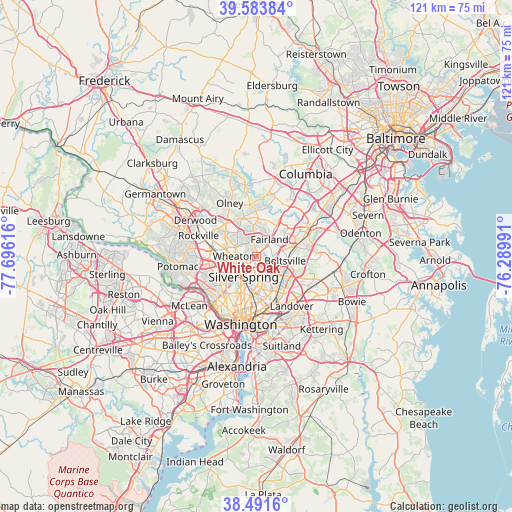
White Oak GPS coordinates[2]
39° 2' 23.388" North, 76° 59' 34.908" West
| Map corner | latitude | longitude |
|---|---|---|
| Upper-left | 39.58384°, | -77.69616° |
| Center: | 39.03983°, | -76.99303° |
| Lower-right: | 38.4916°, | -76.28991° |
| Map W x H: | 121.4×121.4 km | = 75.4×75.4mi |
| max Lat: | 71.29058° ⇑54.4% North |
| White Oak: | 39.03983° |
| min Lat: | ⇓45.6% South 19.06759° |
| min Long | White Oak | max Long |
| -171.73463° | -76.99303° | -66.98998° |
| W 80.6%⇐ | ⇒19.4% E |
Elevation
Elevation of White Oak is 134 m = 440 ft, and this is 160.8 m = 528 ft below average elevation for this country.
| Max E: |
3189 m = 10463 ft | 63.8% |
| Avg. | 294.8 m = 967 ft | |
| White Oak | 134 m = 440 ft | |
Min E: |
-60 m = -197 ft | 36.2% |
See also: United States elevation on elevation.city.
Geographical zone
White Oak is located in North temperate zone (between Tropic of Cancer and the Arctic Circle). Distance of this Northern Tropic circle is 1734.9 km =1078 mi to South.| Distance of | km | miles | from White Oak |
|---|---|---|---|
| North Pole | 5666.2 | 3520.8 | to North |
| Arctic Circle | 3060.4 | 1901.6 | to North |
| Tropic Cancer | 1734.9 | 1078 | to South |
| Equator | 4340.8 | 2697.2 | to South |


Nearby cities:
15 places around White Oak: (largest is in red/bold)
• Adelphi
4.5 km =2.8 mi,  155°
155°
• Calverton
5.3 km =3.3 mi,  68°
68°
• Colesville
4.1 km =2.5 mi,  349°
349°
• Fairland
5.1 km =3.2 mi,  36°
36°
• Forest Glen
6 km =3.7 mi,  242°
242°
• Four Corners
2.8 km =1.7 mi,  218°
218°
• Glenmont
5.3 km =3.3 mi,  292°
292°
• Hillandale
2.2 km =1.4 mi,  132°
132°
• Kemp Mill
2.3 km =1.4 mi,  267°
267°
• Langley Park
5.8 km =3.6 mi,  169°
169°
• Layhill
7.3 km =4.5 mi,  322°
322°
• North Kensington
6.9 km =4.3 mi,  261°
261°
• Silver Spring
6.2 km =3.9 mi,  207°
207°
• Takoma Park
7 km =4.3 mi,  190°
190°
• Wheaton
5.4 km =3.4 mi, 270°
Sources, notices
• [Note1] Compared only with cities in United States existing in our database
• [Src1] Map data: © OpenStreetMap contributors (CC-BY-SA)
• [Src2] Other city data from geonames.org with taken over terms of usage.
• [Src3] Geographical zone / Annual Mean Temperature by Robert A. Rohde @ Wikipedia
