Albany geodata
Albany (Missouri) is a populated place; located in United States in America/Chicago (GMT-5) time zone. With population of 1,791 people, there are 12574 cities with bigger population in this country. Compared to other cities in United States, 52.9% of cities are located further ↑North; 68.9% of cities are located further →East and 57.5% of cities have lower elevation than Albany. Note1


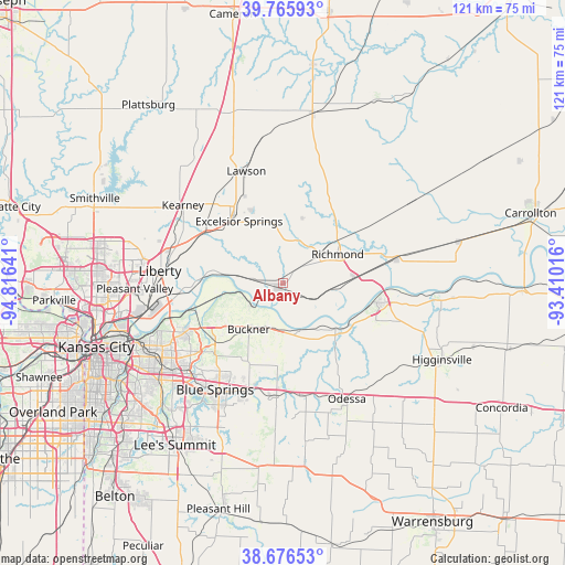
Albany GPS coordinates[2]
39° 13' 24.024" North, 94° 6' 47.808" West
| Map corner | latitude | longitude |
|---|---|---|
| Upper-left | 39.76593°, | -94.81641° |
| Center: | 39.22334°, | -94.11328° |
| Lower-right: | 38.67653°, | -93.41016° |
| Map W x H: | 121.1×121.1 km | = 75.2×75.2mi |
| max Lat: | 71.29058° ⇑52.9% North |
| Albany: | 39.22334° |
| min Lat: | ⇓47.1% South 19.06759° |
| min Long | Albany | max Long |
| -171.73463° | -94.11328° | -66.98998° |
| W 31.1%⇐ | ⇒68.9% E |
Elevation
Elevation of Albany is 228 m = 748 ft, and this is 66.8 m = 219 ft below average elevation for this country.
| Max E: |
3189 m = 10463 ft | 42.5% |
| Avg. | 294.8 m = 967 ft | |
| Albany | 228 m = 748 ft | |
Min E: |
-60 m = -197 ft | 57.5% |
See also: United States elevation on elevation.city.
Geographical zone
Albany is located in North temperate zone (between Tropic of Cancer and the Arctic Circle). Distance of this Northern Tropic circle is 1755.3 km =1090.7 mi to South.| Distance of | km | miles | from Albany |
|---|---|---|---|
| North Pole | 5645.8 | 3508.1 | to North |
| Arctic Circle | 3039.9 | 1888.9 | to North |
| Tropic Cancer | 1755.3 | 1090.7 | to South |
| Equator | 4361.2 | 2709.9 | to South |


Nearby cities:
15 places around Albany: (largest is in red/bold)
• Blue Springs
27.2 km =16.9 mi,  212°
212°
• Buckner
12.5 km =7.8 mi,  216°
216°
• East Independence
25.2 km =15.7 mi,  235°
235°
• Excelsior Springs
16.1 km =10 mi,  322°
322°
• Grain Valley
24.3 km =15.1 mi,  197°
197°
• Hardin
24.6 km =15.3 mi,  77°
77°
• Kearney
26.8 km =16.7 mi,  306°
306°
• Lawson
25.1 km =15.6 mi,  341°
341°
• Lexington
20.6 km =12.8 mi,  102°
102°
• Liberty
26.5 km =16.5 mi,  275°
275°
• Oak Grove
24.3 km =15.1 mi,  183°
183°
• Orrick
1.4 km =0.9 mi, 214°
• Richmond
13.3 km =8.3 mi,  62°
62°
• Wellington
15 km =9.3 mi,  131°
131°
• Wood Heights
13.6 km =8.5 mi, 341°
Sources, notices
• [Note1] Compared only with cities in United States existing in our database
• [Src1] Map data: © OpenStreetMap contributors (CC-BY-SA)
• [Src2] Other city data from geonames.org with taken over terms of usage.
• [Src3] Geographical zone / Annual Mean Temperature by Robert A. Rohde @ Wikipedia
