Wood Heights geodata
Wood Heights (Missouri) is a populated place; located in United States in America/Chicago (GMT-5) time zone. With population of 698 people, there are 18696 cities with bigger population in this country. Compared to other cities in United States, 52% of cities are located further ↑North; 69% of cities are located further →East and 77.2% of cities have lower elevation than Wood Heights. Note1
Administrative division(s):
- Level 1: Missouri
- Level 2: Ray County
- Level 3: Township of Fishing River


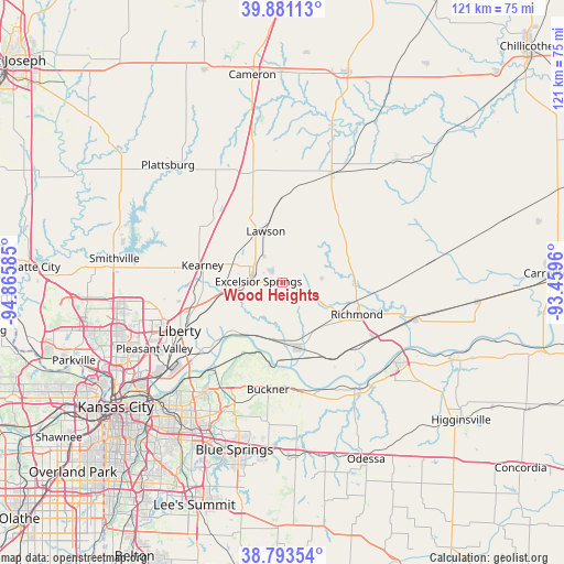
Wood Heights GPS coordinates[2]
39° 20' 22.02" North, 94° 9' 45.792" West
| Map corner | latitude | longitude |
|---|---|---|
| Upper-left | 39.88113°, | -94.86585° |
| Center: | 39.33945°, | -94.16272° |
| Lower-right: | 38.79354°, | -93.4596° |
| Map W x H: | 120.9×120.9 km | = 75.1×75.1mi |
| max Lat: | 71.29058° ⇑52% North |
| Wood Heights: | 39.33945° |
| min Lat: | ⇓48% South 19.06759° |
| min Long | Wood Heights | max Long |
| -171.73463° | -94.16272° | -66.98998° |
| W 31%⇐ | ⇒69% E |
Elevation
Elevation of Wood Heights is 329 m = 1079 ft, and this is 34.2 m = 112 ft above average elevation for this country.
| Max E: |
3189 m = 10463 ft | 22.8% |
| Wood Heights | 329 m 1079 ft | |
| Avg. | 294.8 m = 967 ft | |
Min E: |
-60 m = -197 ft | 77.2% |
See also: United States elevation on elevation.city.
Geographical zone
Wood Heights is located in North temperate zone (between Tropic of Cancer and the Arctic Circle). Distance of this Northern Tropic circle is 1768.2 km =1098.7 mi to South.| Distance of | km | miles | from Wood Heights |
|---|---|---|---|
| North Pole | 5632.9 | 3500.1 | to North |
| Arctic Circle | 3027 | 1880.9 | to North |
| Tropic Cancer | 1768.2 | 1098.7 | to South |
| Equator | 4374.1 | 2717.9 | to South |


Nearby cities:
15 places around Wood Heights: (largest is in red/bold)
• Albany
13.6 km =8.5 mi,  161°
161°
• Buckner
23.2 km =14.4 mi,  187°
187°
• Excelsior Springs
5.4 km =3.4 mi,  269°
269°
• Glenaire
28.1 km =17.5 mi,  242°
242°
• Hardin
29.3 km =18.2 mi,  105°
105°
• Kearney
17.4 km =10.8 mi,  280°
280°
• Lathrop
27.3 km =17 mi,  328°
328°
• Lawson
11.6 km =7.2 mi,  342°
342°
• Lexington
29.8 km =18.5 mi,  125°
125°
• Liberty
24.4 km =15.2 mi, 244°
• Orrick
14.5 km =9 mi,  166°
166°
• Pleasant Valley
30.9 km =19.2 mi, 243°
• Polo
25.9 km =16.1 mi,  23°
23°
• Richmond
17.4 km =10.8 mi, 112°
• Wellington
27.6 km =17.1 mi,  145°
145°
Sources, notices
• [Note1] Compared only with cities in United States existing in our database
• [Src1] Map data: © OpenStreetMap contributors (CC-BY-SA)
• [Src2] Other city data from geonames.org with taken over terms of usage.
• [Src3] Geographical zone / Annual Mean Temperature by Robert A. Rohde @ Wikipedia
