Richmond geodata
Richmond (Missouri) is a seat of a second-order administrative division; located in United States in America/Chicago (GMT-5) time zone. With population of 5,595 people, there are 6683 cities with bigger population in this country. Compared to other cities in United States, 52.4% of cities are located further ↑North; 68.6% of cities are located further →East and 63.1% of cities have lower elevation than Richmond. Note1


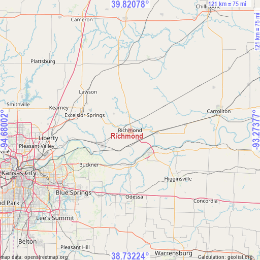
Richmond GPS coordinates[2]
39° 16' 43.032" North, 93° 58' 36.804" West
| Map corner | latitude | longitude |
|---|---|---|
| Upper-left | 39.82078°, | -94.68002° |
| Center: | 39.27862°, | -93.97689° |
| Lower-right: | 38.73224°, | -93.27377° |
| Map W x H: | 121×121 km | = 75.2×75.2mi |
| max Lat: | 71.29058° ⇑52.4% North |
| Richmond: | 39.27862° |
| min Lat: | ⇓47.6% South 19.06759° |
| min Long | Richmond | max Long |
| -171.73463° | -93.97689° | -66.98998° |
| W 31.4%⇐ | ⇒68.6% E |
Elevation
Elevation of Richmond is 253 m = 830 ft, and this is 41.8 m = 137 ft below average elevation for this country.
| Max E: |
3189 m = 10463 ft | 36.9% |
| Avg. | 294.8 m = 967 ft | |
| Richmond | 253 m = 830 ft | |
Min E: |
-60 m = -197 ft | 63.1% |
See also: United States elevation on elevation.city.
Geographical zone
Richmond is located in North temperate zone (between Tropic of Cancer and the Arctic Circle). Distance of this Northern Tropic circle is 1761.5 km =1094.5 mi to South.| Distance of | km | miles | from Richmond |
|---|---|---|---|
| North Pole | 5639.7 | 3504.3 | to North |
| Arctic Circle | 3033.8 | 1885.1 | to North |
| Tropic Cancer | 1761.5 | 1094.5 | to South |
| Equator | 4367.4 | 2713.8 | to South |


Nearby cities:
15 places around Richmond: (largest is in red/bold)
• Albany
13.3 km =8.3 mi,  242°
242°
• Buckner
25.1 km =15.6 mi,  229°
229°
• Excelsior Springs
22.5 km =14 mi,  287°
287°
• Hardin
12.3 km =7.6 mi,  94°
94°
• Higginsville
32 km =19.9 mi,  135°
135°
• Kearney
34.6 km =21.5 mi, 286°
• Lawson
26.4 km =16.4 mi,  312°
312°
• Lexington
13.4 km =8.3 mi, 141°
• Norborne
25.9 km =16.1 mi,  84°
84°
• Oak Grove
33.1 km =20.6 mi,  203°
203°
• Odessa
31.1 km =19.3 mi,  176°
176°
• Orrick
14.5 km =9 mi, 239°
• Polo
30.9 km =19.2 mi,  349°
349°
• Wellington
16.1 km =10 mi, 181°
• Wood Heights
17.4 km =10.8 mi, 292°
Sources, notices
• [Note1] Compared only with cities in United States existing in our database
• [Src1] Map data: © OpenStreetMap contributors (CC-BY-SA)
• [Src2] Other city data from geonames.org with taken over terms of usage.
• [Src3] Geographical zone / Annual Mean Temperature by Robert A. Rohde @ Wikipedia
