Arnold geodata
Arnold (Missouri) is a populated place; located in United States in America/Chicago (GMT-5) time zone. With population of 21,357 people, there are 2364 cities with bigger population in this country. Compared to other cities in United States, 59.1% of cities are located further ↑North; 60.4% of cities are located further →East and 55.5% of cities have higher elevation than Arnold. Note1


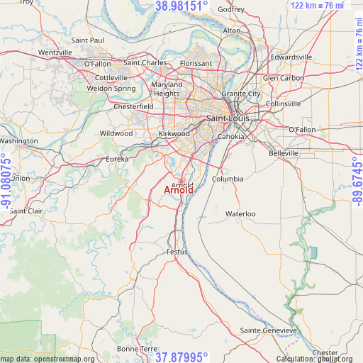
Arnold GPS coordinates[2]
38° 25' 58.188" North, 90° 22' 39.432" West
| Map corner | latitude | longitude |
|---|---|---|
| Upper-left | 38.98151°, | -91.08075° |
| Center: | 38.43283°, | -90.37762° |
| Lower-right: | 37.87995°, | -89.6745° |
| Map W x H: | 122.5×122.5 km | = 76.1×76.1mi |
| max Lat: | 71.29058° ⇑59.1% North |
| Arnold: | 38.43283° |
| min Lat: | ⇓40.9% South 19.06759° |
| min Long | Arnold | max Long |
| -171.73463° | -90.37762° | -66.98998° |
| W 39.6%⇐ | ⇒60.4% E |
Elevation
Elevation of Arnold is 178 m = 584 ft, and this is 116.8 m = 383 ft below average elevation for this country.
| Max E: |
3189 m = 10463 ft | 55.5% |
| Avg. | 294.8 m = 967 ft | |
| Arnold | 178 m = 584 ft | |
Min E: |
-60 m = -197 ft | 44.5% |
See also: United States elevation on elevation.city.
Geographical zone
Arnold is located in North temperate zone (between Tropic of Cancer and the Arctic Circle). Distance of this Northern Tropic circle is 1667.4 km =1036.1 mi to South.| Distance of | km | miles | from Arnold |
|---|---|---|---|
| North Pole | 5733.7 | 3562.8 | to North |
| Arctic Circle | 3127.8 | 1943.5 | to North |
| Tropic Cancer | 1667.4 | 1036.1 | to South |
| Equator | 4273.3 | 2655.3 | to South |


Nearby cities:
15 places around Arnold: (largest is in red/bold)
• Affton
13.7 km =8.5 mi,  16°
16°
• Barnhart
9.9 km =6.2 mi,  187°
187°
• Concord
10.3 km =6.4 mi,  9°
9°
• Crestwood
13.8 km =8.6 mi,  358°
358°
• Fenton
10.3 km =6.4 mi,  330°
330°
• Grantwood Village
13.2 km =8.2 mi, 8°
• Green Park
10.7 km =6.6 mi, 18°
• Imperial
7 km =4.3 mi,  180°
180°
• Lakeshire
12.3 km =7.6 mi, 17°
• Mehlville
9.7 km =6 mi,  29°
29°
• Murphy
11.5 km =7.1 mi,  303°
303°
• Oakville
7.6 km =4.7 mi,  56°
56°
• Saint George
12.8 km =8 mi, 25°
• Sappington
11.6 km =7.2 mi, 359°
• Sunset Hills
12.1 km =7.5 mi,  347°
347°
Sources, notices
• [Note1] Compared only with cities in United States existing in our database
• [Src1] Map data: © OpenStreetMap contributors (CC-BY-SA)
• [Src2] Other city data from geonames.org with taken over terms of usage.
• [Src3] Geographical zone / Annual Mean Temperature by Robert A. Rohde @ Wikipedia
