Imperial geodata
Imperial (Missouri) is a populated place; located in United States in America/Chicago (GMT-5) time zone. With population of 4,709 people, there are 7432 cities with bigger population in this country. Compared to other cities in United States, 59.5% of cities are located further ↑North; 60.4% of cities are located further →East and 64% of cities have higher elevation than Imperial. Note1
Administrative division(s):
- Level 1: Missouri
- Level 2: Jefferson County
- Level 3: Township of Windsor


Imperial GPS coordinates[2]
38° 22' 11.208" North, 90° 22' 42.42" West
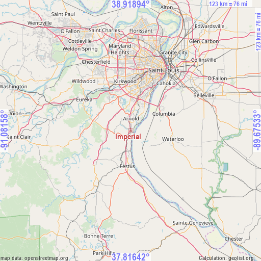
| Map corner | latitude | longitude |
|---|---|---|
| Upper-left | 38.91894°, | -91.08158° |
| Center: | 38.36978°, | -90.37845° |
| Lower-right: | 37.81642°, | -89.67533° |
| Map W x H: | 122.6×122.6 km | = 76.2×76.2mi |
| max Lat: | 71.29058° ⇑59.5% North |
| Imperial: | 38.36978° |
| min Lat: | ⇓40.5% South 19.06759° |
| min Long | Imperial | max Long |
| -171.73463° | -90.37845° | -66.98998° |
| W 39.6%⇐ | ⇒60.4% E |
Elevation
Elevation of Imperial is 133 m = 436 ft, and this is 161.8 m = 531 ft below average elevation for this country.
| Max E: |
3189 m = 10463 ft | 64% |
| Avg. | 294.8 m = 967 ft | |
| Imperial | 133 m = 436 ft | |
Min E: |
-60 m = -197 ft | 36% |
See also: United States elevation on elevation.city.
Geographical zone
Imperial is located in North temperate zone (between Tropic of Cancer and the Arctic Circle). Distance of this Northern Tropic circle is 1660.4 km =1031.7 mi to South.| Distance of | km | miles | from Imperial |
|---|---|---|---|
| North Pole | 5740.7 | 3567.1 | to North |
| Arctic Circle | 3134.9 | 1947.9 | to North |
| Tropic Cancer | 1660.4 | 1031.7 | to South |
| Equator | 4266.3 | 2651 | to South |


Nearby cities:
15 places around Imperial: (largest is in red/bold)
• Arnold
7 km =4.3 mi,  0°
0°
• Barnhart
3.1 km =1.9 mi,  204°
204°
• Concord
17.3 km =10.7 mi,  6°
6°
• Crystal City
16.5 km =10.3 mi,  180°
180°
• Fenton
16.7 km =10.4 mi,  342°
342°
• Festus
16.7 km =10.4 mi,  185°
185°
• Herculaneum
11.3 km =7 mi, 180°
• High Ridge
17 km =10.6 mi,  305°
305°
• Horine
12.1 km =7.5 mi, 199°
• Mehlville
16.2 km =10.1 mi,  17°
17°
• Murphy
16.4 km =10.2 mi,  324°
324°
• Oakville
12.9 km =8 mi,  30°
30°
• Pevely
9.7 km =6 mi, 188°
• Riverside
9.2 km =5.7 mi, 180°
• Valmeyer
11.4 km =7.1 mi,  128°
128°
Sources, notices
• [Note1] Compared only with cities in United States existing in our database
• [Src1] Map data: © OpenStreetMap contributors (CC-BY-SA)
• [Src2] Other city data from geonames.org with taken over terms of usage.
• [Src3] Geographical zone / Annual Mean Temperature by Robert A. Rohde @ Wikipedia
