Dearborn geodata
Dearborn (Missouri) is a populated place; located in United States in America/Chicago (GMT-5) time zone. With population of 506 people, there are 20811 cities with bigger population in this country. Compared to other cities in United States, 50.7% of cities are located further ↑North; 70.6% of cities are located further →East and 69.5% of cities have lower elevation than Dearborn. Note1


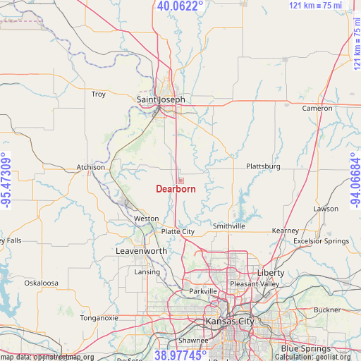
Dearborn GPS coordinates[2]
39° 31' 18.984" North, 94° 46' 11.856" West
| Map corner | latitude | longitude |
|---|---|---|
| Upper-left | 40.0622°, | -95.47309° |
| Center: | 39.52194°, | -94.76996° |
| Lower-right: | 38.97745°, | -94.06684° |
| Map W x H: | 120.6×120.6 km | = 74.9×74.9mi |
| max Lat: | 71.29058° ⇑50.7% North |
| Dearborn: | 39.52194° |
| min Lat: | ⇓49.3% South 19.06759° |
| min Long | Dearborn | max Long |
| -171.73463° | -94.76996° | -66.98998° |
| W 29.4%⇐ | ⇒70.6% E |
Elevation
Elevation of Dearborn is 283 m = 928 ft, and this is 11.8 m = 39 ft below average elevation for this country.
| Max E: |
3189 m = 10463 ft | 30.5% |
| Avg. | 294.8 m = 967 ft | |
| Dearborn | 283 m = 928 ft | |
Min E: |
-60 m = -197 ft | 69.5% |
See also: United States elevation on elevation.city.
Geographical zone
Dearborn is located in North temperate zone (between Tropic of Cancer and the Arctic Circle). Distance of this Northern Tropic circle is 1788.5 km =1111.3 mi to South.| Distance of | km | miles | from Dearborn |
|---|---|---|---|
| North Pole | 5612.6 | 3487.5 | to North |
| Arctic Circle | 3006.7 | 1868.3 | to North |
| Tropic Cancer | 1788.5 | 1111.3 | to South |
| Equator | 4394.4 | 2730.6 | to South |


Nearby cities:
15 places around Dearborn: (largest is in red/bold)
• Agency
13.9 km =8.6 mi,  10°
10°
• Atchison
30.5 km =19 mi,  278°
278°
• Camden Point
8.1 km =5 mi,  162°
162°
• Edgerton
11.9 km =7.4 mi,  99°
99°
• Elwood
27.4 km =17 mi,  341°
341°
• Gower
17.6 km =10.9 mi,  55°
55°
• Leavenworth
26.9 km =16.7 mi,  209°
209°
• Platte City
16.9 km =10.5 mi,  183°
183°
• Plattsburg
28 km =17.4 mi,  80°
80°
• Saint Joseph
28.2 km =17.5 mi,  346°
346°
• Smithville
22.1 km =13.7 mi,  132°
132°
• Trimble
18.5 km =11.5 mi,  107°
107°
• Wathena
30.5 km =19 mi,  329°
329°
• Weatherby Lake
32.2 km =20 mi,  168°
168°
• Weston
16.7 km =10.4 mi,  222°
222°
Sources, notices
• [Note1] Compared only with cities in United States existing in our database
• [Src1] Map data: © OpenStreetMap contributors (CC-BY-SA)
• [Src2] Other city data from geonames.org with taken over terms of usage.
• [Src3] Geographical zone / Annual Mean Temperature by Robert A. Rohde @ Wikipedia
