Smithville geodata
Smithville (Missouri) is a populated place; located in United States in America/Chicago (GMT-5) time zone. With population of 9,233 people, there are 4716 cities with bigger population in this country. Compared to other cities in United States, 51.7% of cities are located further ↑North; 70.1% of cities are located further →East and 62.6% of cities have lower elevation than Smithville. Note1


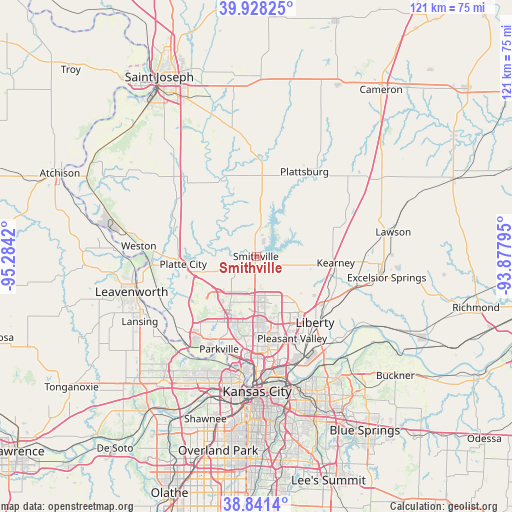
Smithville GPS coordinates[2]
39° 23' 12.984" North, 94° 34' 51.852" West
| Map corner | latitude | longitude |
|---|---|---|
| Upper-left | 39.92825°, | -95.2842° |
| Center: | 39.38694°, | -94.58107° |
| Lower-right: | 38.8414°, | -93.87795° |
| Map W x H: | 120.8×120.8 km | = 75.1×75.1mi |
| max Lat: | 71.29058° ⇑51.7% North |
| Smithville: | 39.38694° |
| min Lat: | ⇓48.3% South 19.06759° |
| min Long | Smithville | max Long |
| -171.73463° | -94.58107° | -66.98998° |
| W 29.9%⇐ | ⇒70.1% E |
Elevation
Elevation of Smithville is 251 m = 823 ft, and this is 43.8 m = 144 ft below average elevation for this country.
| Max E: |
3189 m = 10463 ft | 37.4% |
| Avg. | 294.8 m = 967 ft | |
| Smithville | 251 m = 823 ft | |
Min E: |
-60 m = -197 ft | 62.6% |
See also: United States elevation on elevation.city.
Geographical zone
Smithville is located in North temperate zone (between Tropic of Cancer and the Arctic Circle). Distance of this Northern Tropic circle is 1773.5 km =1102 mi to South.| Distance of | km | miles | from Smithville |
|---|---|---|---|
| North Pole | 5627.6 | 3496.8 | to North |
| Arctic Circle | 3021.8 | 1877.7 | to North |
| Tropic Cancer | 1773.5 | 1102 | to South |
| Equator | 4379.4 | 2721.2 | to South |


Nearby cities:
15 places around Smithville: (largest is in red/bold)
• Camden Point
15.6 km =9.7 mi,  297°
297°
• Claycomo
21.9 km =13.6 mi,  159°
159°
• Dearborn
22.1 km =13.7 mi,  312°
312°
• Edgerton
13.9 km =8.6 mi,  341°
341°
• Gladstone
20.5 km =12.7 mi,  173°
173°
• Glenaire
21.5 km =13.4 mi,  148°
148°
• Kearney
18.9 km =11.7 mi,  96°
96°
• Lake Waukomis
17.9 km =11.1 mi,  195°
195°
• Liberty
21 km =13 mi,  138°
138°
• Parkville
23 km =14.3 mi, 202°
• Platte City
17.4 km =10.8 mi,  263°
263°
• Plattsburg
22.9 km =14.2 mi,  29°
29°
• Pleasant Valley
20.7 km =12.9 mi, 156°
• Trimble
9.5 km =5.9 mi,  8°
8°
• Weatherby Lake
19.3 km =12 mi,  210°
210°
Sources, notices
• [Note1] Compared only with cities in United States existing in our database
• [Src1] Map data: © OpenStreetMap contributors (CC-BY-SA)
• [Src2] Other city data from geonames.org with taken over terms of usage.
• [Src3] Geographical zone / Annual Mean Temperature by Robert A. Rohde @ Wikipedia
