Atchison geodata
Atchison (Kansas) is a seat of a second-order administrative division; located in United States in America/Chicago (GMT-5) time zone. With population of 10,712 people, there are 4263 cities with bigger population in this country. Compared to other cities in United States, 50.4% of cities are located further ↑North; 71.4% of cities are located further →East and 63.1% of cities have lower elevation than Atchison. Note1


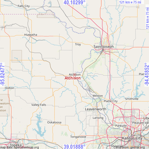
Atchison GPS coordinates[2]
39° 33' 46.98" North, 95° 7' 17.904" West
| Map corner | latitude | longitude |
|---|---|---|
| Upper-left | 40.10299°, | -95.82477° |
| Center: | 39.56305°, | -95.12164° |
| Lower-right: | 39.01888°, | -94.41852° |
| Map W x H: | 120.5×120.5 km | = 74.9×74.9mi |
| max Lat: | 71.29058° ⇑50.4% North |
| Atchison: | 39.56305° |
| min Lat: | ⇓49.6% South 19.06759° |
| min Long | Atchison | max Long |
| -171.73463° | -95.12164° | -66.98998° |
| W 28.6%⇐ | ⇒71.4% E |
Elevation
Elevation of Atchison is 253 m = 830 ft, and this is 41.8 m = 137 ft below average elevation for this country.
| Max E: |
3189 m = 10463 ft | 36.9% |
| Avg. | 294.8 m = 967 ft | |
| Atchison | 253 m = 830 ft | |
Min E: |
-60 m = -197 ft | 63.1% |
See also: United States elevation on elevation.city.
Geographical zone
Atchison is located in North temperate zone (between Tropic of Cancer and the Arctic Circle). Distance of this Northern Tropic circle is 1793.1 km =1114.2 mi to South.| Distance of | km | miles | from Atchison |
|---|---|---|---|
| North Pole | 5608.1 | 3484.7 | to North |
| Arctic Circle | 3002.2 | 1865.5 | to North |
| Tropic Cancer | 1793.1 | 1114.2 | to South |
| Equator | 4399 | 2733.4 | to South |


Nearby cities:
15 places around Atchison: (largest is in red/bold)
• Agency
33.9 km =21.1 mi,  74°
74°
• Camden Point
34.8 km =21.6 mi,  110°
110°
• Dearborn
30.5 km =19 mi,  98°
98°
• Effingham
24.4 km =15.2 mi,  259°
259°
• Elwood
30.2 km =18.8 mi,  44°
44°
• Highland
35.3 km =21.9 mi,  338°
338°
• Horton
36.3 km =22.6 mi,  287°
287°
• Leavenworth
32.8 km =20.4 mi,  148°
148°
• Nortonville
24.4 km =15.2 mi,  228°
228°
• Platte City
36.2 km =22.5 mi,  126°
126°
• Saint Joseph
32.8 km =20.4 mi,  45°
45°
• Troy
24.6 km =15.3 mi,  6°
6°
• Wathena
26.3 km =16.3 mi,  34°
34°
• Weston
25.3 km =15.7 mi, 131°
• Winchester
29.5 km =18.3 mi,  204°
204°
Sources, notices
• [Note1] Compared only with cities in United States existing in our database
• [Src1] Map data: © OpenStreetMap contributors (CC-BY-SA)
• [Src2] Other city data from geonames.org with taken over terms of usage.
• [Src3] Geographical zone / Annual Mean Temperature by Robert A. Rohde @ Wikipedia
